

|
|
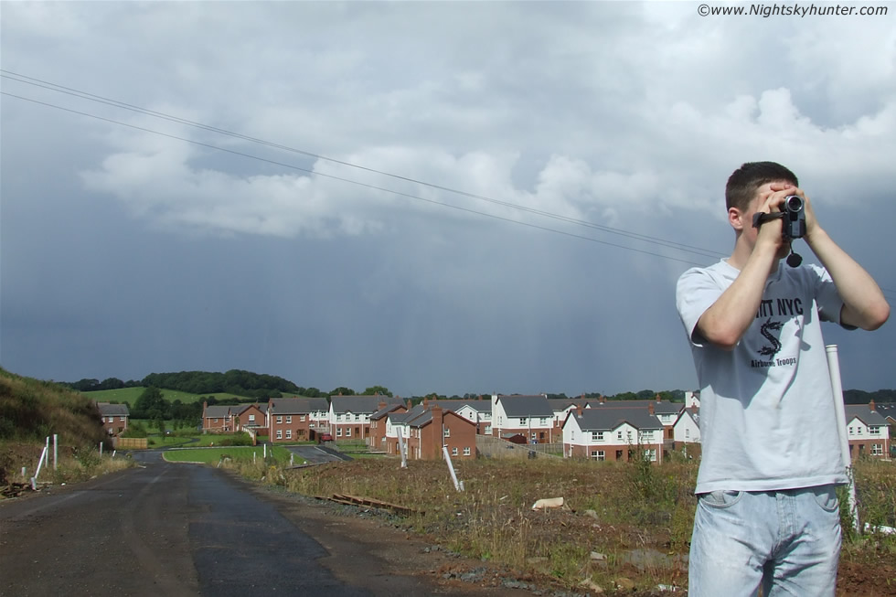 |
Dense curtains of hail drifting north accompanied by thunder and c-g lightning over The Glynns, Maghera during the afternoon of July 17th 2007. In the foreground Conor McDonald zooms in on the approaching storm with his camcorder. A large funnel cloud would appear moments later to the east instantly turning the day into a roaring success and changing our lives forever.
Widespread Thundery Activity for much of UK & Ireland 09Z-21Z
Convergence Derived Funnel Activity N.Eire & N. UK 12Z-21Z
Slight Risk of Meso Tornado Oxford through to Norfolk and surrounding counties 12Z-18Z
If we look at the surface airstream across the UK today we can see that originates from somewhere in the Mid Atlantic. Hence the cool surface temps expected. Lapse rates are unlikely to be as steep as we would like to see today though there is room for solar heating during the afternoon which could sway the balance somewhat. Particular note needs to be made to PVA. This has been lacking lately and could easily increase the potential for deep lift especially where it interacts with upper shear. Almost a north-south divide today with moderate instability to the north and shear to the south with some subsidence in between! This boundary IMO could be breached later this afternoon as lapse rates increase. With 20 kts shear expected up to 850mb and a 45 deg directional shear we do in fact just have enough potential for a vertically sheared tornado or two. Further directional and speed shear are above this level acquiring the basic parameter for rotating storms. I think (except for south coast) we all have a pretty good chance of seeing a thunderstorm today and possibly the odd funnel. Source: UK Weatherworld.
Tuesday July 17th 2007 was another interesting day for anyone interested in severe weather and storm chasing in N. Ireland. During the previous evening, July 16th, Conor and I had a very successful chase to the top of Slieve Gallion mountain which was an experience which we didn't expect to beat for some time, you can read the chase report HERE. The 17th was another hot humid Summer's day and convective clouds had been boiling up in the form of beautiful white Cbs or cumulonimbus dominating the weather between periods of blue sky and strong sunshine. By late afternoon a storm was brewing up and I heard the first cracks of thunder following bright flashes of lightning which got my curiosity going. I was standing at my backdoor watching the activity with a mug of tea planning in my mind the kind of images I hoped to get in a few min's time when the storm got closer. I was thinking about my mate Conor McDonald who could be absolutely anywhere today, with his keen interest in weather like this I was sure he had his eye to the sky no matter where he was located. The time was 16.00 BST and it was at this moment when I heard the sound of a car moving swiftly through my estate with an engine in high rev and dust billowing into the air from the wheels, whoever the driver was he was in a serious rush. I looked out the front window and realized with delight that it was Conor with his girlfriend Christina which had confirmed my suspicion that he had been watching the convective action intently!
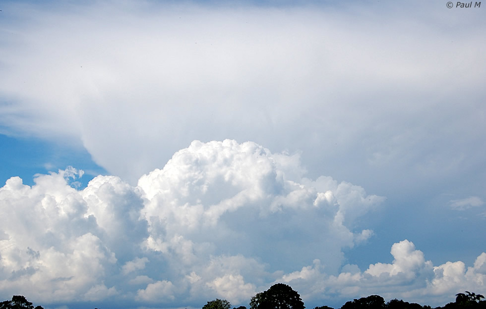
Conor parked his car at a strategic location on a large hill which gave an excellent view to the horizon and no doubt he planned to take advantage of the topography in the hope of catching this storm with his digital camcorder. I grabbed my own bridge camera and jogged up to the parked car to join Conor and Christina who were already studying the sky. The dark belly under a large anvil passed over dumping heavy rain and hail forcing us to take shelter inside the car which we were very glad to have. The hail was thumping the car and bouncing off the narrow road and within the darkened sky, and through the rain smeared window, we could see the staccato style strikes of numerous cloud-ground and in-cloud orange coloured lightning strikes which seemed to appear at random. Perhaps 30 sec's later the core of the storm passed us by so we exited the car and walked across the muddy rain-soaked road as the rain free base drifted over our heads. Hot rays of splendid sunshine hit the back of our necks as clear gaps appeared in the sky. The storm was passing from SW to NE at a very slow speed and facing N we could see a white fibrous wall consisting of dense falling shafts of hail stones and rain. It was at this point that we were rewarded with the largest convective clouds we have ever witnessed in our lives as three giant Cbs towered into the sky, one in the N and other two in the SW and E. The anvils on top were both beautiful and menacing in profile with their sharply defined wedge-shaped gleaming white thunder heads stretching for a breathtaking distance in azimuth and reaching to the zenith where it competed with the Sun for attention. The most impressive anvil was the one in the E which was so long that it covered the entire NE to SE sky sector!
To the N the hail curtains where dumping their icy deluge over the rooftops of Willow Glynn and on into the surrounding countryside. Rapid orange coloured c-g lightning strikes provided us with plenty of action which was followed with loud reverberating rolls of thunder which was the strangest I have ever heard. The thunder did not stop, but continued for at least five min's without a break!!!. I already had the camera in action and by this stage I had squeezed off 100 images at a fast shutter speed in the hope of catching a lightning strike. I reset the camera from 5MP to 3MP (which I now regret as the resolution was down) to provide me with more images to play with as the space on my 256MP memory card was quickly depleting. I crouched down and knelt against the front bumper of Conor's car to steady my arms and took another 100 shots while Conor took video footage of the retreating storm. While previewing my images Conor and I discussed the finer points of the storm and about the funnel cloud and tornado risk which had been issued for N. Ireland today, we had always wanted to see either a funnel cloud or tornado which had been a primary goal for us and we wondered if we ever would, especially after we had tried so hard during yesterday's chase up the mountain.
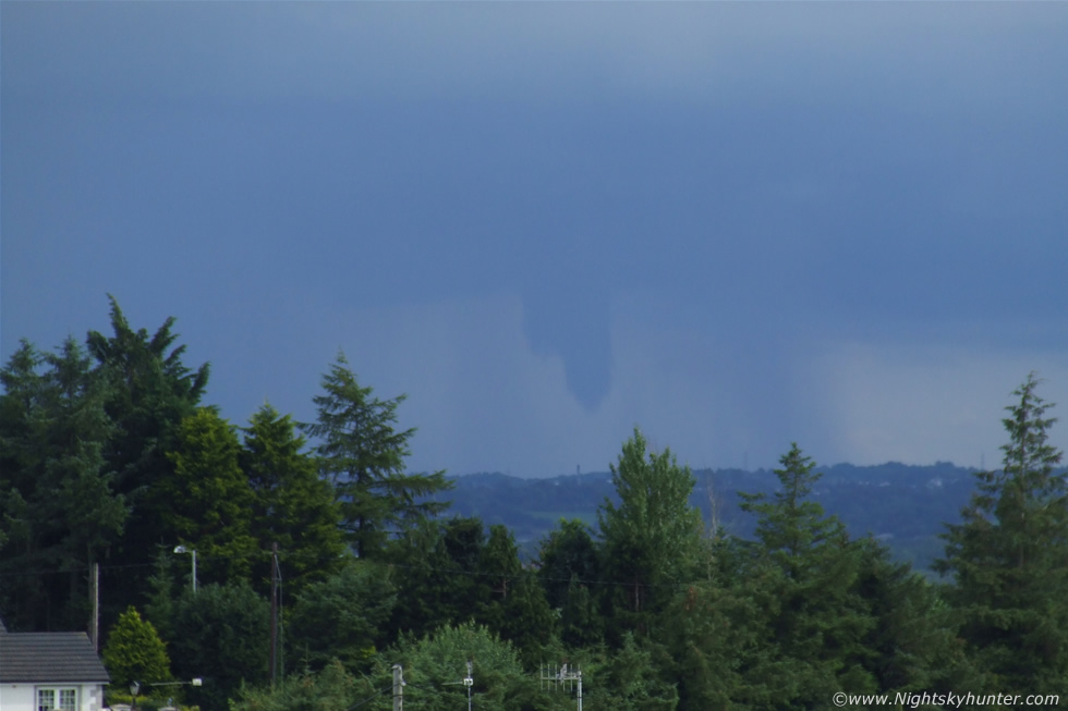
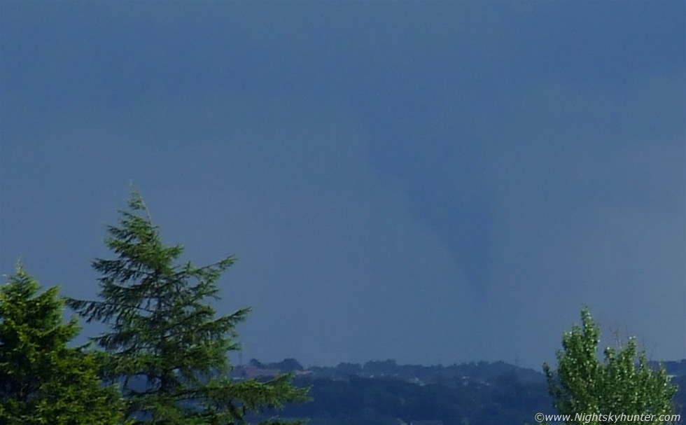
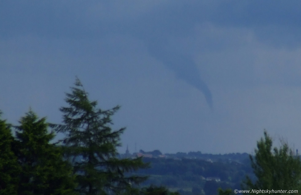
As the lightning disappeared to the N I glanced casually over my right shoulder facing toward the SE when I suddenly got a severe shock, hanging down from the W edge of the rain free base and below the giant anvil was a bulging black funnel descending downward. I could barely speak a word so I just pointed in the general direction shouting ''Conor!!''. I had never seen a real funnel before however I knew instantly that this was one of exceptional size. Things suddenly turned crazy and time seemed to slow as our eyes took in the scene. I was focused on the funnel so much that I got very narrow tunnel vision as nothing else around me existed any more. We immediately went into combat mode in order to get a photographic record of what was happening, this was what we had dreamed about and now we needed reactions and discipline. I recall thinking at the time that all those hundreds of hours spent taking images of weather and astronomical subjects would pay off during a moment like this.
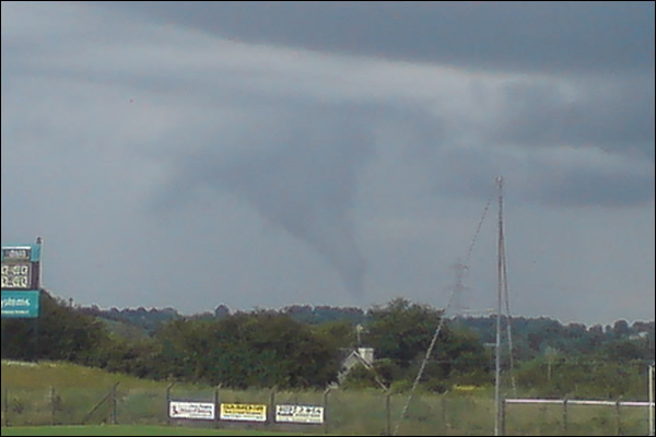
We got into position and Conor began shooting video footage while I began taking images which was a major challenge as I had to set the camera between 150mm and 200mm to get a decent close up while trying to hold the camera steady and at this magnification it was no easy feat and my shaking hands (due to the excitement) did not help matters. Manually focusing the camera was a nightmare as sunlight was reflecting off the LCD screen which resulted in me seeing little or none of the funnel through it so I just kept snapping while shifting the focus in and out which turned out to be a good decision. The funnel had now lowered half way to the ground, stopped, then started to ascend again before lowering back down flirting with the ground. At this stage it was now a large wedge and over time its 'snout' began to narrow and lower all the way to what seemed to be the ground. A narrow pencil thin condensation funnel extended from the bottom and appeared to touch the Earth on at least two occasions. At this stage we were frantic with adrenaline and Conor suggested that we gave chase in the car to see the spectacle up close. As the three of us began running to the car the funnel began to get even more exciting so we stayed our ground and continued watching as it narrowed and twisted into a classic tornadic shape before it rose in height and 'roped out'. The long narrow tube seemed to drag in the air pointing to the SW then split at the centre leaving two dark tubes hanging in the sky before they both dissipated into the air. The funnel had gone. It was visible from 16.35 - 16.50 BST for a duration of 15 minutes.
After we collected our thoughts all three of us believed it had touched down on the ground making this a possible tornado, but where did it touch down? In that direction where the small towns of Gulladuff, Lavy, and Magherafelt. I reckoned that someone else, possibly driving through the countryside must have seen this. Even though it was many miles distant from us it still had a large apparent diameter in the sky so it must have been of exceptional size. We parted company and reported our account with images and footage to the UKWW for discussion. I followed this up by contacting several newspapers and the BBC with the intention of hearing about other sightings. Below is a selection of images I took of the funnel...
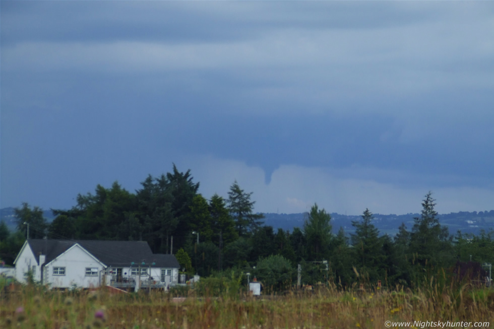 |
Looking SE at the main updraught area of the huge storm. Funnel is dropping out from the rain-free base. Note the area of heavy hail falling to the L. Cell is moving from R to L. Updraught base looks slanted also.
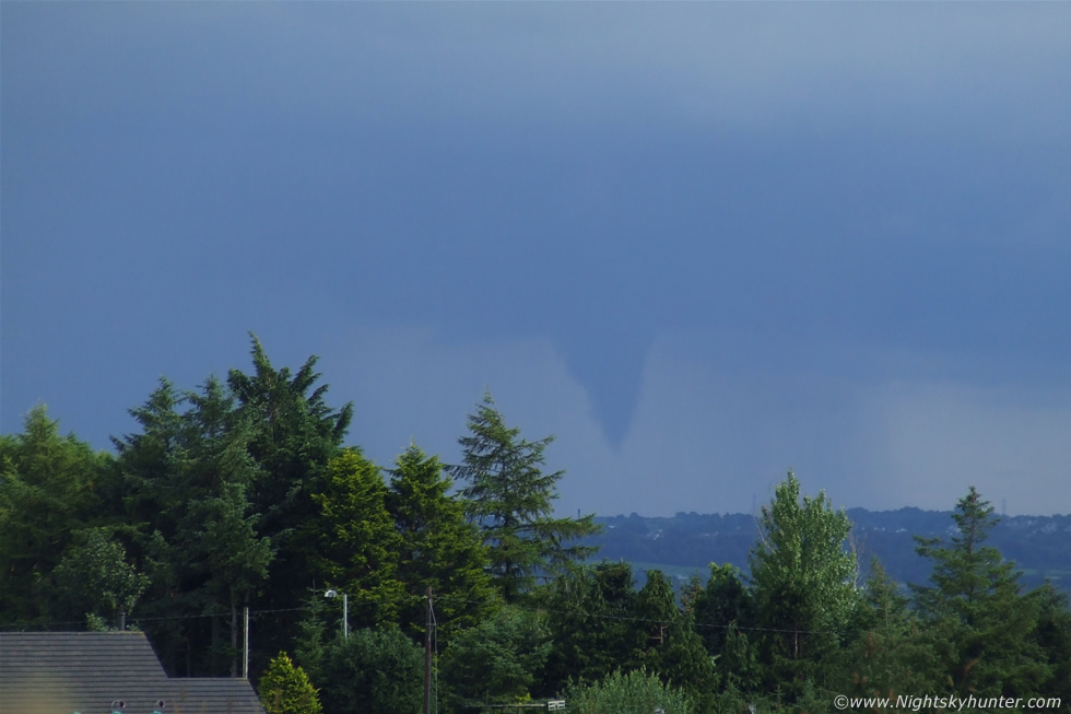 |
Funnel getting much bigger and with a huge wedge-shaped profile
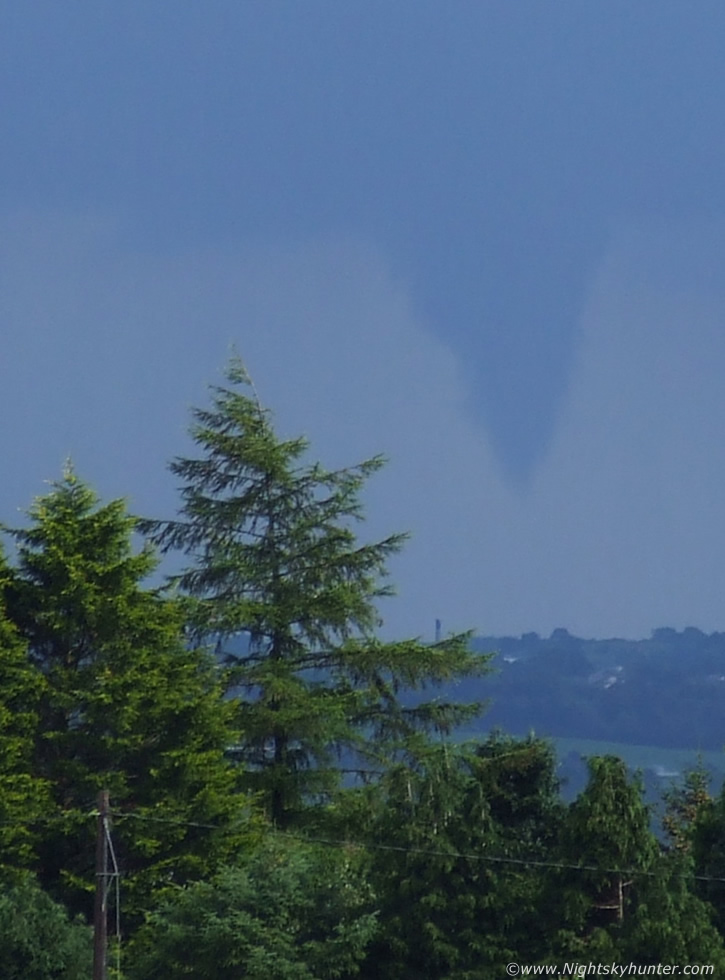 |
Cropped in close from the original frame. I was beside myself with excitement, I couldn't belief this was happening and also how big it was. Conor and I where shouting and roaring and cursing out loud and making comments about what we were seeing along with the rapid changing shape, much of that conversation I can't quote on here as it would be for adult ears only.
 |
Powerful motions going on here indicated by the twin 'bulges'.
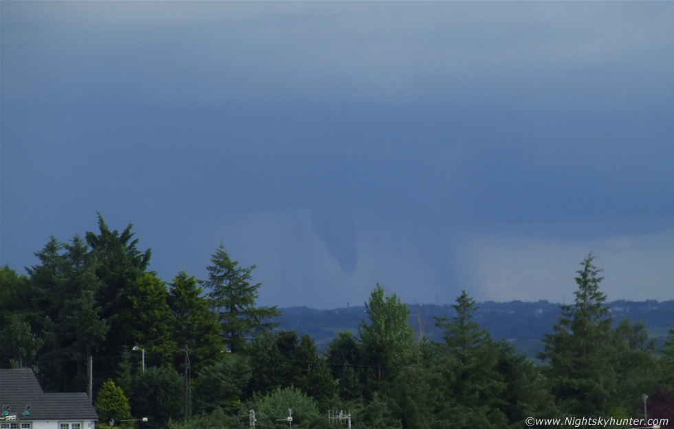 |
The two bulges have merged into a single entity and began to take on a slender form.
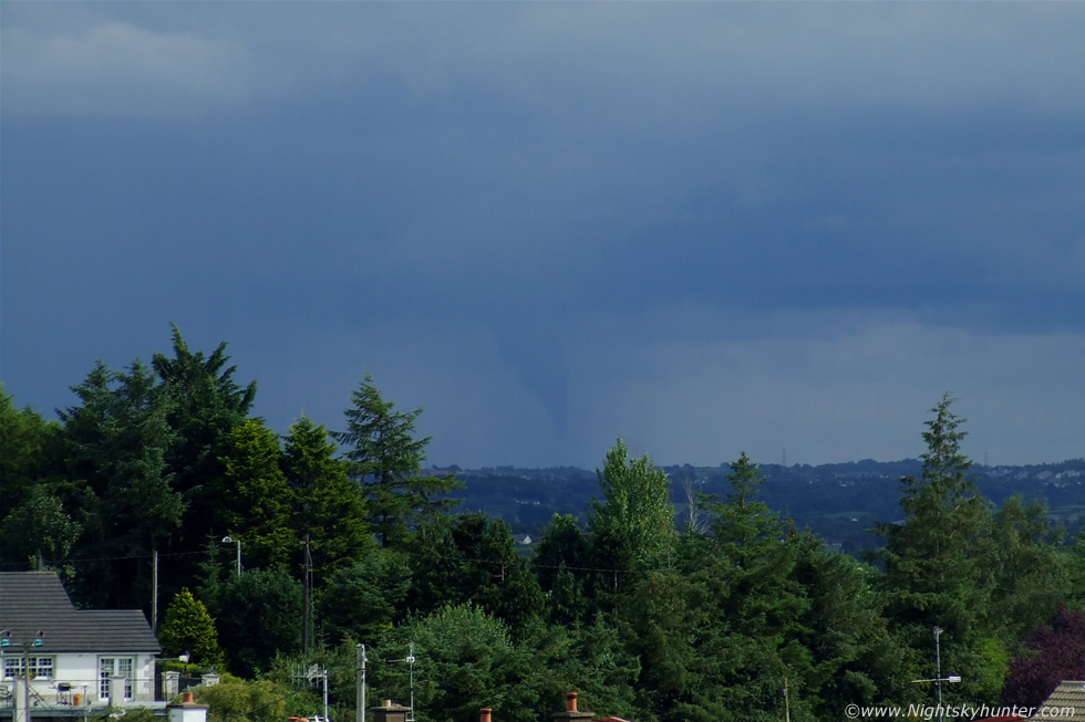 |
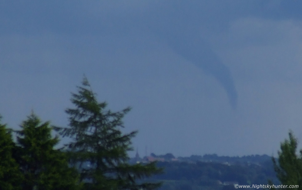
Extremely close to ground contact here. There was a transparent condensation funnel extending down from the main funnel which tried its best to reach down to Earth. Note the bulges to the LHS of the funnel indicating rapid rotation.
 |
Can you get much closer than that?. Almost a full blown tornado, there must have been surface effects from this, during the excitement we both agreed that if this where on the ground it could be strong enough to overturn a car, it certainly looked that way from it's size and the way it was moving. Note faint debris under the funnel, see below for a very tight crop.
 |
Deep crop. If only I could do justice by explaining to you the changing shape and rotation however it would be impossible for me to do so, you really had to have been there to have seen it. I'm sure my jaw was on the floor at this point. Several veteran storm chasers from the USA and Australia have pointed out to me that this image and the one above appear to show actual debris our dirt directly under the condensation funnel which implies that this circulation was probably on the ground and hence a tornado.
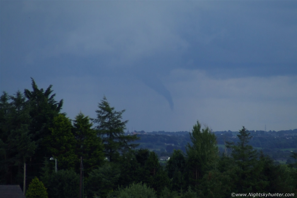 |
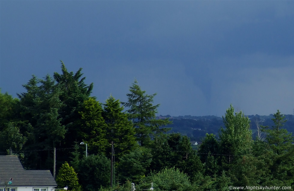
Funnel lifting back up again while curving gracefully into the classic tornadic profile. As I watched I kept thinking was this N. Ireland?, it looked more like Tornado Alley.
 |
Another deep crop. As we watched, this menacing looking tube twisted and probed the air unsure what to do next, it lifted up into the air then back down again as if deciding whether to touch down or not with the snout seemingly sniffing the air, watching it do what it wanted was an unbelievable thrill while thunder rumbled in the distance.
 |
More slender and continuing to bend as it lifted. This was awesome to watch.
 |
Cropped in close, oh how I wished I had a proper DSLR and telephoto lens to do this justice, however I had to use what I had and what I could afford, these were taken with my trusty Fujifilm S5600 bridge camera however despite the low resolution and difficult operating mode I still felt proud that I had caught it.
 |
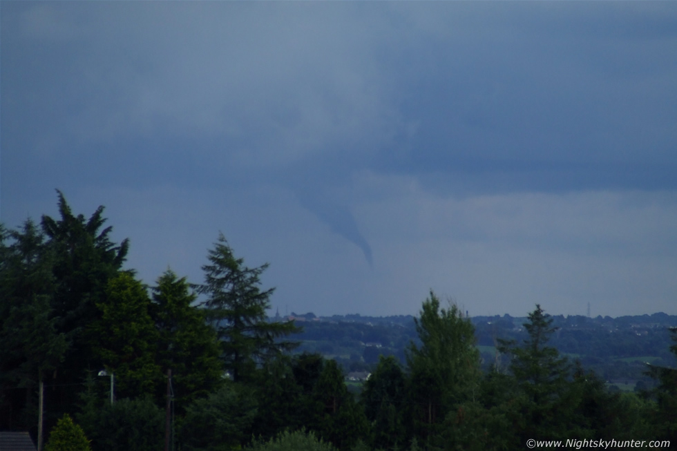
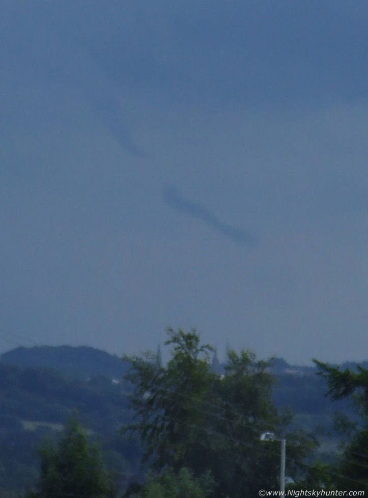
Funnel weakening and roping out. Horizontal striation lines clearly visible at image top.
 |
Complete rope-out. Funnel breaks in two while both sections continue to rotate.
 |
Cropped in from the above, watching this was like watching a dark bloated worm dissected in two with both segments of the tube still rotating in the sky.
 |
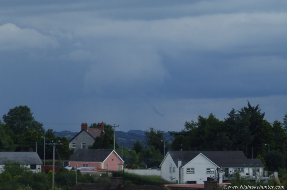
This image was taken 15 min's after the funnel from Toome and was kindly sent to me by Paul M. This was the storm which produced the funnel except we where on the other side of it (W). You can see the huge anvil above, a quick check on the BBC weather website showed that someone else had seen the very same funnel.
 |
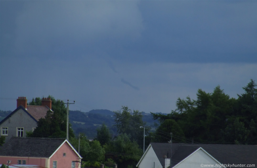
One lady from Coalisland had taken this excellent image with her mobile phone camera showing the funnel almost touching the ground. (name unknown).
A few weeks later I received an email from expert Tornado investigator Dr.John Tyrrell from the University of Cork, S. Ireland. John is a prolific and highly experienced tornado damage detective and does field work for the 'Tornado & Storm Research Organization' (TORRO). John and I began corresponding via email and I gave him all the information I knew on our funnel sighting. He also had chosen a number of key features on the horizon on my images asking for their identification such as buildings, pylons, and a distant chimney stack of very distinctive shape, however it was too difficult to make a positive ID so I gave him a vague location where I suspected the funnel had been, which was a number of miles away and possibly over the vicinity of Mc Cann's quarry. John informed me that he would be visiting N. Ireland the following week for a field investigation and I suggested meeting him when he arrived although the exact date hadn't been decided on yet.
Several days later I arrived back home after doing a little weather photography in the Maghera countryside when my Sister informed me that she had seen a car with a southern number plate up on the hill and a man looking at a map. I put two and two together and walked up the hill to his location and said ''excuse me but by any chance are you John?'' and the reply was ''hello Martin'' followed by a handshake...it was Dr. John Tyrrell from TORRO and what a coincidence it was. Was I impressed?, you bet!, because with very little information and nothing more than an image with a narrow field of view he was now standing on the exact spot where Conor and I had seen the funnel.
We talked about the sighting and surveyed the horizon with binoculars matching up features visually with what was on a black and white print out of my image, which was cross-checked with John's OS map of the area. Plotted on it was the other sighting from Coalisland which he used to triangulate a position. This was followed by an educational chat about funnel clouds and tornadoes in Ireland, their Summer and Winter frequency, trends and relative intensity. I learned that the topography of the land has just as an important relationship to play in tornado development as the convective activity in the atmosphere. John discussed some past cases in Ireland which was fascinating and quite an eye opener. Out of local interest I asked him about the tornado which hit Aghalee on New Year's Eve 2006 (there where two within as many years in that area) and he showed me a map with his plots showing the damage track through a very large area naming the land and villages it passed through in detail as well as it's track across Lough Neagh as a waterspout which was educational to say the least. I was very impressed with his attention to detail and logical scientific methodology. The second tornado which hit Aghalee actually damaged the property of a home belonging to the Brother and Sister of a good astronomical friend of mine called John McConnell who now drives the very car which was lifted off the ground by the large tornado...it's funny how things come together to create such synchronicity!. I let John get on with his work and if he found any damage track then he would call me the following day and we would visit the location together.
The following day Dr. Tyrrell arrived in my neighborhood during the late afternoon with his investigation almost complete. He told me that he had found the location but it wasn't exactly the result I had been hoping for. After hours of driving, interviewing witnesses, and visiting locations, John had discovered that the funnel did not make contact with the ground which explained why no damage had been reported, however what was surprising was the funnels distance. The chimney stack on the my images turned out be a key feature of the Mid Ulster Hospital and the red-bricked building to the R on the images was Magherafelt police barracks. This put a new angle on things. Further more, the funnel only appeared to touch the ground from my location because as one travels with distance in that direction the ground gradually sloped in a downward gradient which we could not perceive from Maghera. There seems to have been at least another witness located near Ballyronan Marina along the shore of Lough Neagh, the individual concerned was on holidays at the time but will be making contact with John when he returns.
The actual location of the funnel turned out to be within Ardboe not far from an abandoned airstrip which is quite astonishing as this is a great distance from our observing location meaning the funnel must have been of very large size indeed. As it turns out John found a family from Ardboe who not only saw it near it's end stage but managed to get images and video footage using their mobile phones which clearly showed the funnel rotating very rapidly, and the time matched perfectly, however Conor and I were the only witnesses who seen the entire formation and roping-out of the funnel. John had marked these observations on his OS map and said he would send me a complete version from Cork which was extremely kind of him. After three days in N. Ireland John had succeeded and got a positive result, no doubt this completes yet another of the many funnel cloud and tornado cases he has investigated in this country. I found John to be a very friendly intelligent man who would make a great detective, and if he doesn't mind me saying so his dedication and attention to detail reminds me of special agent Leroy Jethro Gibbs from NCIS.
This was followed by another fascinating conversation about tornadoes and I asked him how he got interested in this field, the answer was a passionate one which engaged my interest even further. One tornado event in S. Ireland was so intense that large mobile homes had been thrown over a 12ft fence, and there wasn't even a mark on the fence itself suggesting the homes were much higher when airborne. His description was very vivid and I understood why he was interested now. John took some time out to visit my home where I showed him a few funnel cloud and weather images of my own which was very kind of him to check out and give his time, then he left to prepare for his long drive home. John if you are reading this I would like to thank you for your time, for sharing your interest, for going out of your way to keep me informed, and for being a fascinating individual. You now have me hooked on tornadoes.
Just to clarify for any readers who don't know, a funnel cloud is a tornado in the air, when it doesn't make contact with the ground it's called a funnel cloud however once contact has been made on the ground with obvious debris or damage then it becomes a tornado. A tornado may develop from a funnel but contact with the ground is the defining difference between the two labels much in the same way a meteoroid, meteor, and meteorite are three different stages of the same event depending on where it is. It's interesting to note that had the funnel extended lower, or higher ground was located underneath, then the July 17th funnel could very well have touched down.
One thing is for certain, I will never forget the events which took place on this day and I'm glad to have been involved with such a rare event, an experience which I was delighted to share with Conor and Christina. This funnel was the most exciting daytime natural phenomena I have ever witnessed to date and it took me a full two weeks to come down from the 'high'. I have now developed a keen interest in such events and extreme weather with the hope of observing more of these spectacular transient events. I will be introducing more severe weather related events and images here so keep checking back to nightskyhunter.com for updates. Thanks very much for reading.
Despite no obvious damage being found at the site location one has to ask if this was a tornado?. Conor and I were the only observers who witnessed the entire life cycle of this funnel from an elevated position and we both had the impression it was affecting the ground however there where no eyewitnesses at close range or underneath the funnel to confirm if there were any ground effects at the time, and any ground effects over open countryside would not be obvious to the untrained eye anyway, especially if the vortex was weak or over an area which has little or no dust or to reveal ground contact or with the view obscured by trees.
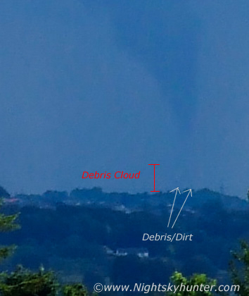 |
Furthermore it is well known by experienced storm chasers and tornado scientists that the visible condensation funnel does not have to be observed reaching the ground for a tornado to be present, in fact, the invisible section of the vortex often extends much further down than what one can see with the naked eye, with that being said chasers who see a funnel two thirds of the way to the ground will often call it a tornado for this very reason and considering just how substantial, well defined and close to the ground the Ardboe funnel is on several of these images - does present a case for a tornado based on this reasoning alone. The above image is a very deep crop from images 8 and 9 which seem to show a faint debris cloud directly below the funnel, the white arrows point out at least two large pieces of debris in the air - possibly leaves, branches, or dirt stirred into the air a considerable height by the vortex, these features are not present on any of the other images except the main image showing the funnel at it's closed point to the ground which is very compelling. So was this an actual tornado caught in the act? - quite possibly!.
Martin McKenna