

|
|
I have lost count of the amount of days I've spent on the road chasing severe weather this year, if I count all the ice and snow events during the Winter as well then the true figure is quite astonishing, why do I do this?, mainly for the thrill however my real motivation is in the hope of experiencing thrilling events and returning home with a great digital trophy in the form of images showing great structure which capture in vivid style the weather we can get here in N. Ireland. The challenge is great due to the unpredictable nature of the weather and restrictions in funds or fuel. I have done more chasing in 2010 then I have during any other year to date so at least I can say I'm doing my best to get results in the hope of getting lucky and catching something truly spectacular on camera. I once read that 'luck' was when preparation meets opportunity, I don't believe in luck however I do like that definition as I can identify with it, after all, I had preparation in abundance so all I needed was the opportunity. Those have been few and far between this year as far as convective set-ups are concerned, however despite a rather poor storm season I have been fortunate enough to witness a number of incredible events this year which have spurred me on to keep trying and never give up.
July 21st 2010 would be my last chance for a while to catch good thunderstorms, and after missing two days of the finest storms during the previous week I was determined to get something cool. This determination peaked at an intense level on the evening of the 20th when many people reported sightings of funnel clouds over N. Ireland in the Antrim area, I had actually been out that day on the W side of Lough Neagh near Ardboe watching for them however the clouds in that region were mushy at best so I got nothing more than sunburn for my troubles at the expense of yet more fuel. The images I saw of those beautiful funnel clouds made me feel extremely focused to say the least so I decided I was going to give it my best on the 21st, after all it would be my last chance for a while as a ridge of high pressure would be moving over the country in the days ahead. I spent alot of time on Facebook during the previous night chatting with UK chaser Danny Power and N. Ireland chaser Paul Martin, we posted with growing excitement about the set-up and came up with a plan based on the current data, due to convergence and high CAPE I decided that SW Lough Neagh would be the place to be for storms, I set my heart on it and had already imagined standing there on the shore while I typed on the computer. Later I was admiring the starry sky after 02.00 BST when I saw a beautiful blue flash of lightning illuminate the sky to the SW among the stars, this was produced by storms below the border and I took the omen as a good sign.
I went to bed late as usual feeling very excited about the chase and the thought of the unknown. I had set my alarm for 09.00 as things could get off to an early start and I didn't want to miss anything. My mind was so focused that I actually awoke three times during the night ready to go, feeling fresh and alert, on the third time the clock read 06.10 so I went back to sleep again thinking that I had got one up on the clock and had extra hours to sleep that I hadn't expected. Woke up again at 09.00 and got out from my bed in an instant and switched the computer on. Things looked very exciting indeed, the latest GFS update had stayed with it's trend during the previous days with high instability across the country, in fact there was already +600 CAPE over NI at 09.00 however the instability would move S during the afternoon which is why southern areas where the best place to be. Between 12.00 and 15.00 there was 1300 CAPE and LI's between -3 and -4, this was excellent instability for this country and anyone who had even a vague understanding of the charts would have got excited by this.
Things looked good however the devil was in the detail so I needed to make a good call on where I was going to be today because I had no mobile internet access so my decision now would make or break the day. The flow was coming from the N, this would later change to a NWly which I noted with great interest, this meant that during prime heating time any storms would be blown to the SE of the country, for this reason I decided against the W and SW side of Lough Neagh. TORRO had issued a convective discussion for t-storms, hail, funnel clouds, and weak tornadoes, they made reference to the high res models showing several convergence zones to the E and SE of N. Ireland, and it was there where they had placed their risk box. This was the reason I changed my target area, convergence zones are the place to be so there was no doubt about the hunting area now. However fuel in the car was low so I couldn't go too far, I would have liked to have went to SE of the Lough but that wasn't going to happen today so with petrol concerns in mind I decided to go E of central Ulster with the intention of hitting Co. Antrim on the NE side of the Lough, I was committed. The Met Office had issued a severe weather warning for heavy rain, flooding, and thunderstorms. Things would get interesting during the afternoon when a trough moved across the country creating additional lift, and with great lapse rates I was 100% certain there would be good storms today, shear was poor however the convergence could compensate for that in some way.
I decided to take my Mum storm chasing with me since she was on holidays and fancied going out somewhere, we went out on a number of chases during 2009 which she really enjoyed so she was quite excited about the idea once again as this always made a conversation topic with her colleagues when she went back to work, ''what did you do over the holidays?'', ''I went storm chasing'', that always sounds cool and different. We would make an adventure from this day so we quickly got organised with coats, food, camera gear and we where on our way. By this stage it was raining in Maghera so we were glad to get away. We drove down the carriageway, forgot something, and had to go back again however I wasn't worried as it was still early in the day. We drove back onto the carriageway again and in the wing mirror I saw a gust front with heavy rain following us. I asked my Mum to drive today, this was a strategic move on my part because it allowed me time to study my road map and keep an eye on the sky and take images through the window while on the move, it felt like a breath of fresh air.
We drove to Antrim, originally we where going to position ourselves near the airport but decided against it and instead decided to park up in the Marina on the NE shore of Lough Neagh. This was a beautiful place with several decent car parks, public toilets, and a nice shop/cafe for visitors. I decided we would make this place our base as the view was fantastic across the Lough. I felt like I was on holiday because the Sun was out and it felt very humid, even my Mum who has no knowledge of storm forecasting commented that it felt like a day for storms. There was a lovely deep river cutting through the Marina where its mouth merged with the Lough, on the river where dozens of boats and cruisers while many Ducks and Swans happily bathed in the Sun while visitors soaked up the great atmosphere, it reminded me of Lower Lough Ern in Co. Fermanagh where I used to spend several weeks each year fishing. The sky was looking dreadful though, convection was weak and sorry looking and had that cold Winter-type look which made me feel frustrated, the way things were going I doubted I would see anything decent, at least I had several hours to wait for development.
To kill time we went for a long walk around the Marina then had a nice picnic under the hot Sun while the Lough licked the shore making me feel thirsty, if anything at least I was getting a top up on the tan. Later I noticed significant convection across the Lough on the NW side, the sky was dark under the towers and precip could be seen behind, I kept an eye on them and noticed they where moving SE towards this area, as they got closer the towers became much more spectacular and my instincts told me we were in action. It was then that I realised this was a convergence line with convection bubbling up rapidly in the heat, suddenly thunder rumbled to the E/SE, then another rumble, another, and another, just when I was trying to get my bearings on the location I got a rumble to the N where that convergence line was so the chase was on. The line was near us but not close enough so we needed to move a short distance N where there was a better view away from the tall trees surrounding the nearby golf course. It was my job to choose the roads and take the correct option to get on the storm, we drove through an industrial estate passing 'Junction One' where a funnel was sighted the previous day then took a route to the R, I wanted to stay on the minor roads because once caught on the M22 motorway we would be stuck with nowhere to pull over.
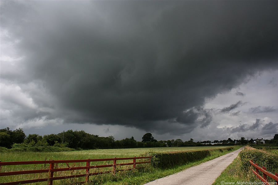 |
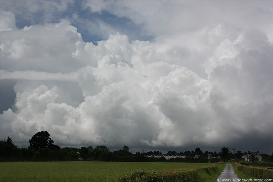
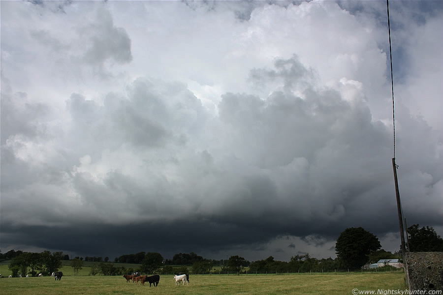
Between the buildings I could see great storm clouds in the distance, they looked really nasty and low to the ground with a black precip line, this was obviously our storm on the convergence (CZ for short) line. We drove through a railway crossing, which always scares the hell out of me even though the lights weren't flashing, and I spotted a lay by on the LHS of the road which we took and stopped. I had done well if I say so myself, we were in a perfect position to watch the storm with an unobstructed flat horizon. This looked like the entrance to private property however the lane towards it was so long that I doubt the owner would have been bothered, that's if they even seen us at all. This is looking NW at the storm which is moving directly towards us, the dark solid cloud is an updraught base on a line of updraughts which towered high overhead, the base was solid and meant business, the black colour of the clouds contrasted nicely with the bright and lush green field which made for a nice foreground. A low rumble of thunder growled from the precip to the L of centre and I was happy because no matter what else happened I had already succeeded, anything else would be a bonus.
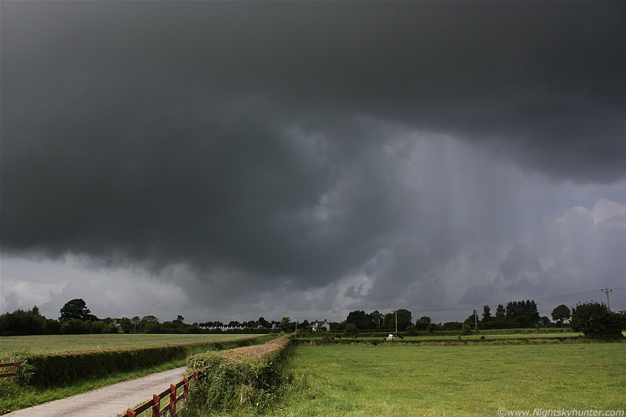 |
The leading end of that dark updraught base is now directly overhead, the clouds to the LHS had great motion which I pointed out to my Mum, we could see the black cloud tags rising up into the base with swift speed, I suspected a funnel cloud was possible so I set the video camera on the car roof and let it record for 5 min's incase one dropped, I might even catch a c-g in the process. On the RHS heavy precip began to break out and the clouds overhead merged into a line of convection which formed a gust front which extended far out of frame to the R. The heat and humidity was very intense now, sweat was pooling on my face and arms and my t-shirt began to stick to my skin.
 |
Turning 90 degrees to my R and looking E at the other side of this system, that's the S end of the gust front where new precip lines were forming and meeting with the others to the N. These are all at 18mm so this structure was very big, it looked very menacing over that house, in the distance you can see more towers growing which would turn into storms later in the SE. The precip was almost on us and soon the Sun would be gone killing the photo opp so I told my Mum to get back in the car because we were already in the danger zone, if there was any more lightning then we could get struck, there's nowhere safer than inside a car, that's the place to be as long as you don't touch anything metallic. Good job we got in because a few min's later the outflow from this storm hit us with force, we were astonished at how intense the precip was, it must have suddenly intensified within min's, we were hit by torrential rain and decent sized hail which assaulted the windscreen with a loud 'cracking' noise when each stone hit, the hail was only pea size however it was being driven with great force, we could see the stones bouncing off the ground along with torrents of water running down the road as if a power hose had been the culprit. After 10 min's the precip cleared though and I had a great view of Whale's Mouth structure overhead which looked really cool.
The Sun was out again so we went back to our base at the Marina where we had another brew and enjoyed the Sun. It was now well into the afternoon and dramatic changes had taken place, I could see sharp convection crossing the middle of the Lough heading E, I watched the base for a while incase a waterspout formed however the cell seemed to behave. Towards the E and SE the sky was dark blue where more distant storms put on a great show, I got several text messages from Declan O'Doherty informing me of the latest on the radar, there was a huge anvil over Newtonards, the cell it belonged to would later produce two very large funnel clouds which would make it onto the news the following day, one of the funnels looked close to becoming a tornado. I noticed new convection forming on the CZ line again across the Lough, the towers looked stunning even at that distance so I immediately decided we needed to intercept that line as these looked like the best I had seen all year.
 |
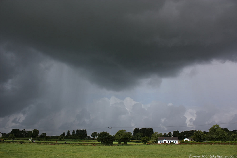
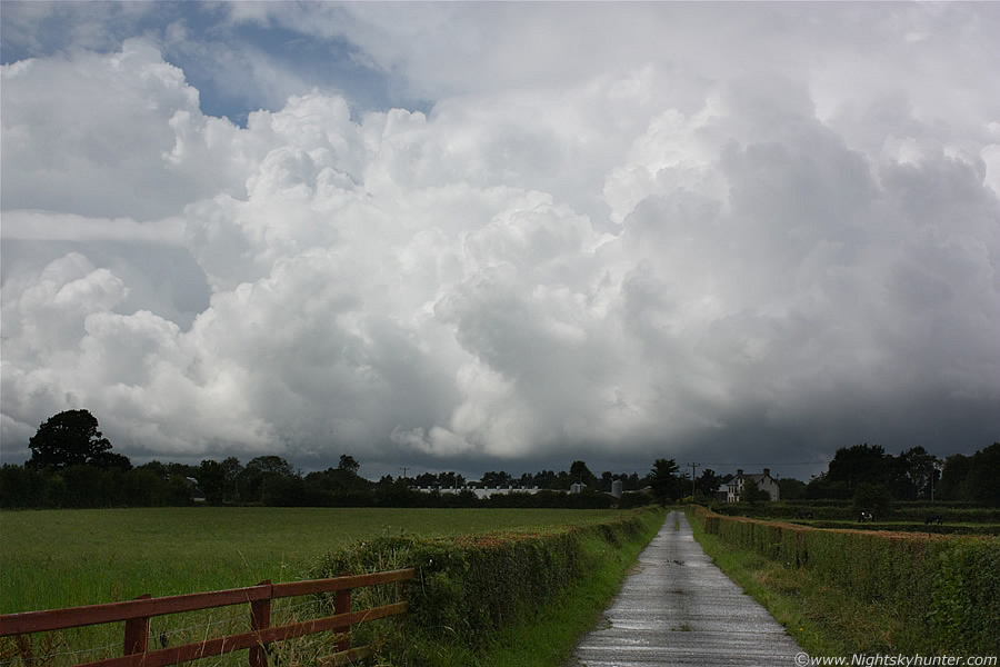
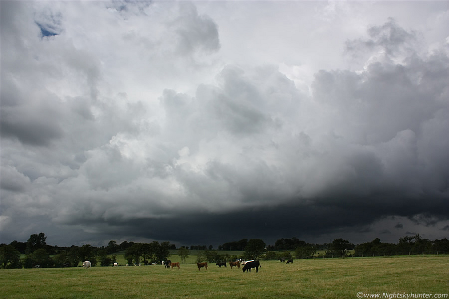
We drove back out again, through the industrial estate, over the railway crossing, and pulled over at the same location as earlier, there was no need to try another because this was perfect, if it ain't broke don't fix it. The view from here was pure eye candy, the CZ line stretched for many miles across the sky, NW to SE, and on that line was a row of incredible convection which was the very finest I have witnessed this year and on par with the top class storms clouds I saw in 2009. Intense Sun, hot temps, humidity, and convergence is a great combination in conjunction with a very unstable atmosphere, the clouds just exploded towards the heavens!. Even these images don't convey how large and crisp those clouds were, on show were towering cumulus, Cb Calvus and Cb Incus cells all packed tight to one another, each cell was rock solid, huge in size, and boiling in real time.
 |
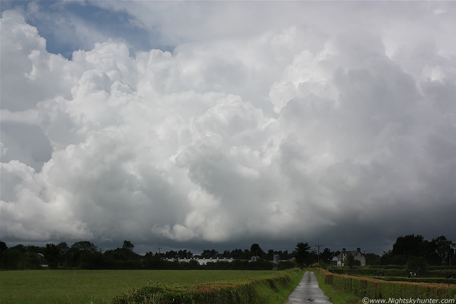
They looked quite a sight all lit white by the bright Sun with the closer tops and cauliflower knuckles showing various shades of white and grey which looked very complex and well defined visually. The bases were dark below and precip was falling from several of them. The line is moving from L to R and very slightly towards us at the same time. Due the slack flow the movement was at a Snail's pace so they barely moved at all which gave me plenty of time to take images and watch for funnels. Taking still images wasn't easy because I wanted to catch their brilliance without overexposing the scene. The tower on the far L has a straight back edge, these where miles away but still looked massive as they proudly sparked to life along the skyline.
 |
We watched this line for a very long time, it was a good chance to teach my Mum all about the convection. Behind the line was another hugging this one tightly, I could see the huge solid tops of cbs with Calvus tops and several anvils far above those towers, not the wispy stuff either, it was proper hard convection indicating serious air currents inside. There was much mid level cloud shielding those distant cb tops, in this image there's one on the RHS which you can't see for this very reason, I got glimpses of it in the gaps and it extended far above the frame of this image. It felt great standing here watching nature at work in the hot Sun while storms popped up over a wide area, at this point I was glad I decided on the NE of the Lough.
 |
I set up the tripod on this road and let the camera record the convection for a long time in the hope of making a time lapse video clip showing the cloud's lively vertical motion, however I just realised I didn't have the correct software to speed up the clip to the sufficient amount required, Windows movie maker wasn't suitable for this so I binned that clip and instead just kept the hand held video. There was light precip falling from overhead so I had to constantly dry the lens on both the video and still camera. We had the local radio turned up loud in the car, the story was about the storms and how a severe weather warning had been issued by the Met Office for heavy rain, there were reports of flooding on the motorways with such intense rainfall that drivers had to pull off the road. We had seen this ourselves earlier from the previous storm, the country roads were like a river at times with huge puddles extending half way across the road. It was cool hearing the warnings while watching this line of storms develop at the same time, the precip falling from these in the background was already causing problems on the roads.
A car pulled up beside us, we thought it was the owner of this property who was going to give off about us parked here however it turned out to be a false alarm, the driver wanted to know the direction to Maghera which was kind of funny since that's where we live, he said he knew he was going the wrong direction when he saw the storm clouds. By this stage of the afternoon things were going nuts across E and SE NI, in Belfast there was constant thunder for several hours, in Newtonards there where several very large funnels twisting in the sky, one of which looked close to being a tornado. In Co. Armagh the storms produced so much rain that 4ft of water was on the main roads which flooded shops. I was still committed to this line and soon I was rewarded when a huge cb exploded up just to the L of centre, I didn't want to wait on it to come here so we decided to give chase.
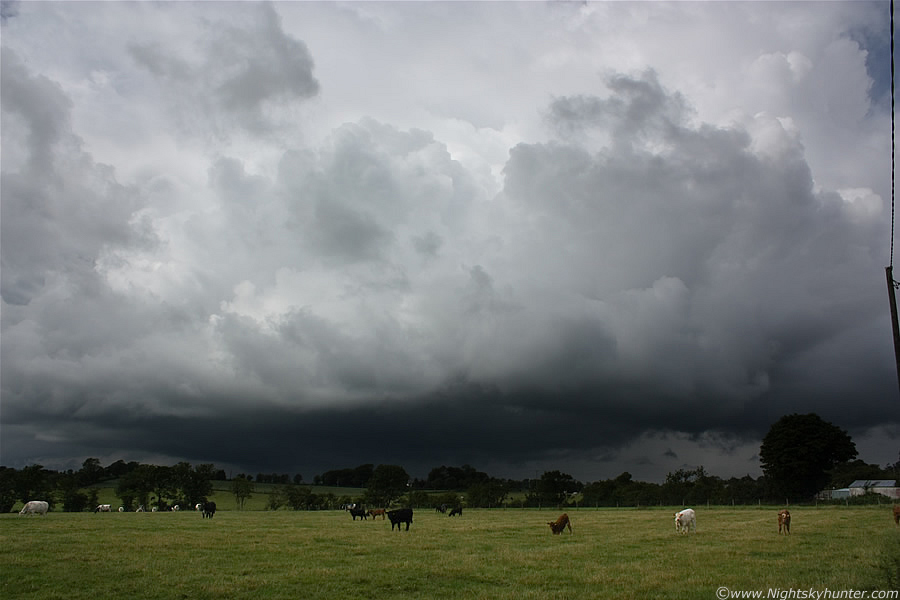 |
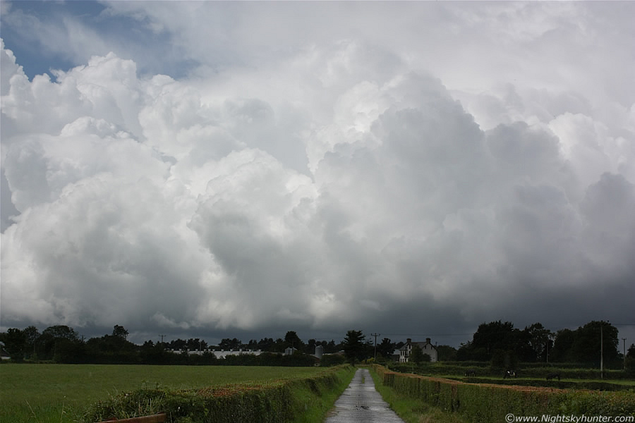
We drove through the wet country roads trying to avoid the restrictive motorway so this narrowed down our options, I wanted to stay in the country but didn't know the area very well so I just made up the directions as we went along based on where the storm was located, it was pure instinct if anything, ''take a left here'', ''take a right there'', ''stay on this road and go straight ahead'', we found a good long road which lead directly to the cell, it was absolutely perfect, the view of the cell out the window was absolutely stunning, I couldn't wait to get stopped and take images. We found a little lay by on the LHS beside a gate to a field and pulled over. The cell looked incredible over the bright green fields with the Cattle grazing below. The storm was too big to fit in the frame. The cloud tops glistened in the bright Sun while far below the base was pure black over the fields where heavy precip was falling in the distance. I climbed over the gate into the field and took images which got the attention of the Cows, you can see one of them in the process of getting up in response to my intrusion.
 |
This is the only shot I got which shows the updraught with the foreground in the same frame, the atmosphere was so energetic that it soon rose higher out of the frame. The storm was VERY slowly moving from L to R and slightly towards us. I managed to get all these images exposed perfectly (except the above still) showing the real bright and dark highlights of the cell at various stages of it's girth. The above image was the exception, it was overexposed which makes the base look brighter than it was, in reality it was pure black under there. I know my Canon 450D inside out, I can read a scene and exposure for it fairly accurately within a few sec's, I have honestly used it on so many days and nights since I got it in Feb that I can navigate the menus and buttons on the body with my eyes closed due to the fact that I have used it so many times in the dark for astronomical photography, it's just muscle memory. Having said that it wasn't plain sailing because the bright high elevation Sun was reflecting on the LCD screen and dazzling my vision, especially when I admired that bright Cb tower. As a result I couldn't really tell if the images were exposed correctly or not. After taking a shot I would go back to the car then preview the image on the screen with the camera held low down into the foot well where it was dark, once my eyes adjusted I could tell if the results were good enough, thankfully they were.
 |
These are all 18mm wide angle, this is the side and rear of the cell, on the LHS explosive towers were going up at the back, as my eye panned across from L to R those towers climbed in height in stair step fashion towards two huge central towers of immense size, easily the tallest cell (s) I have seen this year without exception. I was literally saying ''wow'' out loud as I watched in amazement along with a few other choice words which I won't repeat on here. The precip falling from this storm was now playing havoc on the roads below. There was a Bull in the field to my L which gave me too much attention so I got a little nervous standing in this field. Suddenly an angry rumble of thunder retorted through the atmosphere making its way across the fields towards me which boomed for 5 sec's which got my attention once again. More on page 2.
Martin McKenna