

|
|
I had such a good feeling about this day, GFS was showing 800-900 CAPE over N. Ireland during the afternoon with LIs of -2 however there was no vertical wind shear to speak of and a lack of solar heating was expected to be an issue so on the whole this didn't look like the ideal set-up for storms so why I was getting a good feeling?, the answer is convergence, or more specifically a significant convergence zone was located directly over central N. Ireland and it was this single factor alone which really got my attention because there was a very real chance of funnel clouds and weak tornadoes. A convergence zone is an area where different wind fields meet, and when they do so they create an environment of lift/forcing where thunderstorms and rotating winds are spawn. I was up early monitoring the situation and initially the sky didn't look good with a milky Sun and stubborn clouds with cold temps which had storm killer wrote all over them. A few half decent towers went up by late morning and my chase partner Declan O'Doherty caught a very brief funnel cloud under the base of a towering cu outside of town on his camera phone so that was an encouraging start.
Precip was falling and outside the sky began to get interesting with dark threatening clouds sporting strange motion so I decided to get away from the computer and head outside for a visual on the sky, I called around to Declan's house and the both of us drove into the Maghera countryside and pulled over at an old-faithful look out point on a hill and studied the sky. The centre of a low pressure system was directly over N. Ireland so we where literally located within its 'eye' so to speak, this was obvious when looking at the sky as the entire dome of clouds was slowly rotating around our position which was pretty amazing to watch. To our N and NE was dark precip from showers which were left over from the passage of the cold front which passed through during the morning hours however it was the sky to the E and SE of town which really got our attention. An area of cloud spanning across 100 degrees of sky was 'dancing' before our very eyes and within this area where three large sections of rapidly rotating tendrils of scud, these were part of a messy outflowy cloud formation and not attached to a base however they were clearly rotating with intent so it was obvious that convergence was showing what it could do so early in the day. We came to the conclusion that with motion as good as that for 12pm then things could only get better during the afternoon, if we could get one decent cell or tower to go up in that convergence zone then we could get a major funnel, we even joked that things would kick off around 15.00 BST.
We went back home again, I had a quick lunch to increase energy levels and went back to the computer to see what was happening. By the early afternoon things where kicking off and we were eager to get back out again and do a proper chase however we just needed to find a target. The radar showed a large mass of moderate precip out W with a few red echoes inside showing that area was intensifying fast while shifting slowly to the E so intercepting that was one option, there where other echoes to the SW which might arrive here later however confidence was low, I had a feeling that large area of precip out W might produce the goods once it arrived over central regions where it could take advantage of the better CAPE and interact with the convergence zone but at this stage it could go either way, there wasn't a single sferic in the country and there was a possibility the stuff out W could just produce cloud and rain all afternoon and no storms at all. Outside the Sun was providing some heat however it was through a veil of cirrostratus which surprisingly got to work on the clouds outside so I began to get that good feeling again. Back on the computer we were faced with the same situation, where would our target area be?, then suddenly several c-g sferics showed up N of Lough Neagh, radar showed nothing there so perhaps it was a dry tower going up and the start of a growing storm so this became our first target of the day.
Declan and I got the gear packed into the car and drove outside of town with the intention of intercepting the source of those sferics at the Lough, we were in good spirits, eager to see something cool, and fully prepared to drive a considerable distance to catch a storm today. We stopped at the junction near the main Glenshane carriageway with indicator flashing to the L however our eyes where looking to the R, the sky in that direction to the SW near Glenshane Pass looked quite stunning with a large area of dark and heavy precip falling over the mountains and great solid storm clouds visible along the flank and leading edge of the system, visually it looked like the place to be but since there was no lightning we let it go and took our L option and drove on down the main road. Amazingly we could see nothing in the sky ahead of us towards the Lough where that sferic had come from and we began to second guess our target and the more we looked over our shoulders and in the wing mirror which displayed those menacing clouds over the mountains it dawned on us we would be making a big mistake if we drove any further. Sometimes you need to trust your eyes and instincts and ignore what the charts are showing and go with your gut feeling because 9 times out of 10 it's correct, so that's what we did.
We pulled off the road half way between the two targets and Declan checked the sat images via his laptop, once the page was refreshed it showed absolutely nothing over the Lough, that was a critical point in our day because it stopped us from chasing a ghost and saved us valuable time. We got out on foot for a look and knew in an instant those clouds over Glenshane were 'talking' big time and that we needed to get closer so we got back on the carriageway and backtracked W, the cloud formations looked great out the windscreen so we decided to pull onto the shoulder on the W side of the road to get images of the clouds over the busy road, and it was from this position that our exciting experience unfolded. I set-up my suction window mount on the roof of the car, attached my video camera and let it record the evolving storm clouds above the main road, then Declan and I got busy taking still images and observing the details of the clouds. Cars and trucks raced by and on occasion there was the sound of a horn for our benefit. The sky darkened considerably and the clouds turned beefy as the system stirred, there was alot going on with great motion all over the sky with precip in the distance and another line of cells approaching us from the S behind Slieve Gallion so we where actually located between two groups of cells, however it was the W group which had our full attention.
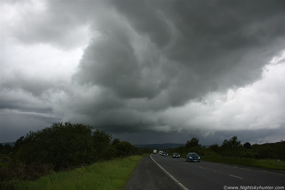 |
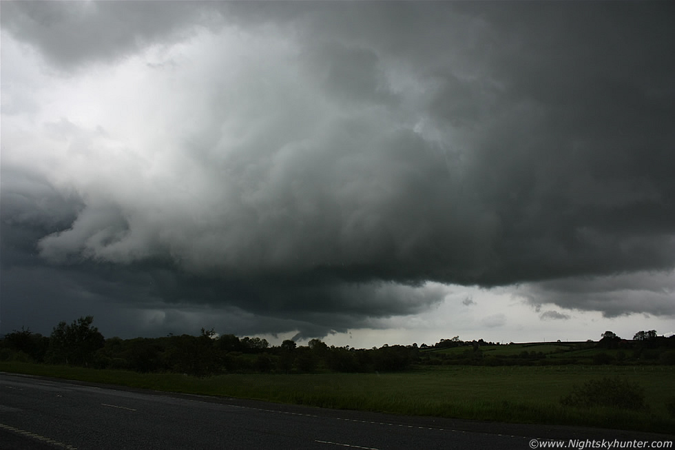
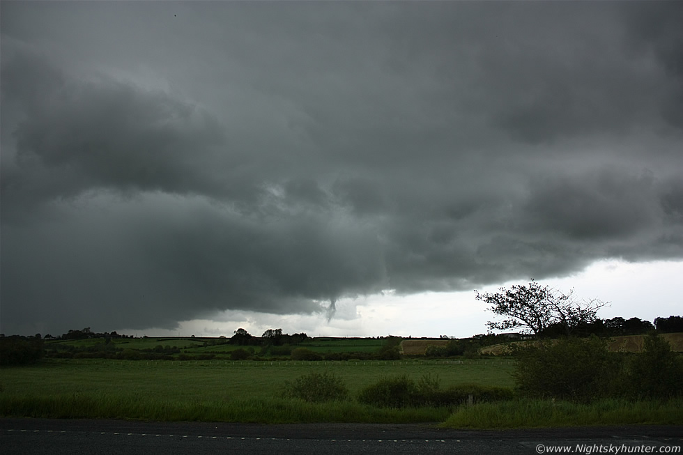
This was the view from our position on the shoulder on the main Glenshane Road looking W to NW towards the Sperrins. In the distance is a band of heavy precip which was very slowly moving L to R and towards us, this belonged to a large line of cells orientated N-S on the radar moving E which was intensifying by the min. Ahead of that band of precip is a formation of clouds, that was the base of an updraught which had gone up and now concealed by mid level cloud, however the base was rotating persistently over those fields which became the focus of our attention.
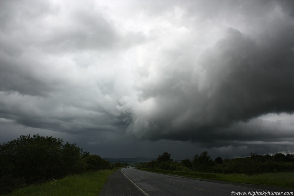 |
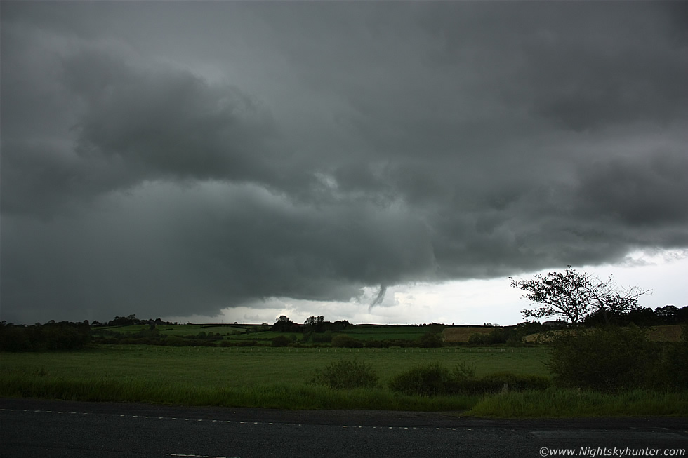
Now a little later, in the background is that precip band on the multicell line, to the RHS you can see the outflow cloud structure as a gust front/shelf cloud and in front of this is our target cell with solid towers now crossing the road in front of us with it's impressive rotating base. I suspect this cell was forced up by the outflow from the line behind it which acted like a miniature cold front creating a source of forcing for convection ahead of the band. In this image its moving L to R and slightly towards us sucking scud tags into the base and rotating in a very exciting manner, we knew this was going to produce something soon, however we hoped it would do so before the precip arrived and hid any vortex which might form. We were happily taking still images of the nice storm structure while the video camera did its thing while the cells approached closer. Suddenly a blue cloud to ground (c-g) bolt struck down behind those trees to the R followed by rolling thunder and it was game on. This had now changed into a storm which began to grow more active by the min.
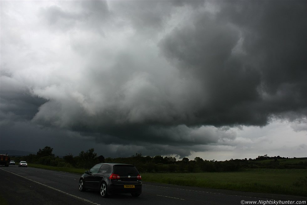 |
It was all happening at this stage with great storm structure and regular thunder/lightning with fantastic rotation along the cloud base, this thing was cranking around rapidly and it wasn't long before we were shouting at it to put down a vortex, the spinning cloud base was really teasing us at this stage.
 |
We were really pleased with the structure and addition to that was the periodic blue flashes of lightning and thunder rumbling across the road as the storm kept growing towards maturity. There was rapid rotation under the base at image centre and at one stage a stubby white-coloured cone-shaped lowering appeared for a few min's before vanishing, if you look carefully you can see it in the two images below, we came so close to getting a vortex then the rotation eased in that area. Hail began to fall and was making that nice metallic sound when it bounced off the car body, a sound which I love to hear, hail is often an indication of a healthy storm with decent updraught so this was a very good sign. We put up with the hail hitting our heads and watched carefully because the storm was up to new tricks.
 |
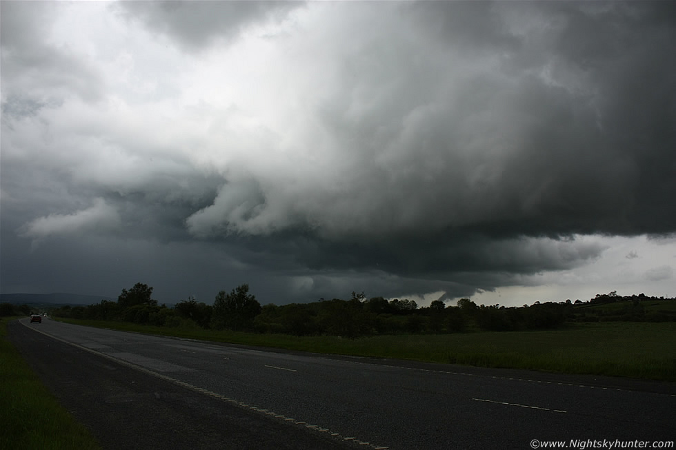
The storm looked fantastic passing over the busy road then 'hovering' over the fields on the N side of the carriageway, the Sly/SWly flow was so slack this day that there was barely any forward movement at all, I don't think we had ever seen such slow moving storms before, this was to our advantage though as slack flows are prolific funnel producers and it also made chasing easy as we could drive ahead of the storm if we wished with enough time for strategic positioning, however none of that was needed as we where at the best location possible with a clear view of the updraught base.
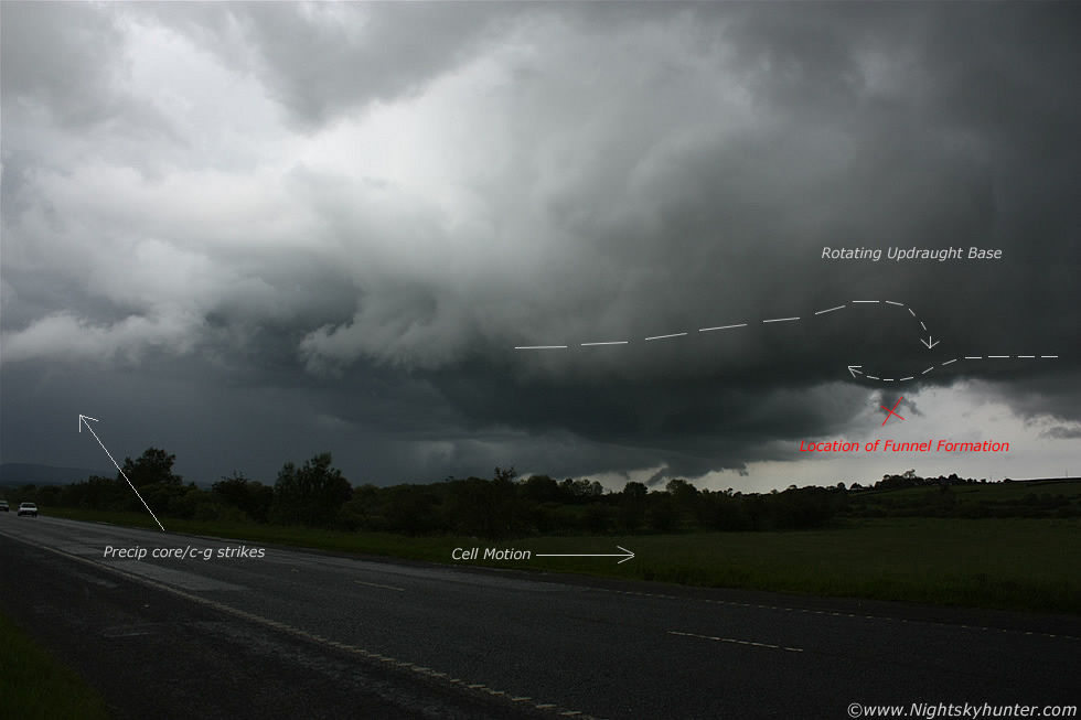 |
Here's an annotated version of what was going on, to the LHS was the outflow/precip core where c-gs struck down in the fields and to the centre is the rotating updraught base, forward motion of the cell was to the E at a Snail's pace while a new significant area of rotation developed to the RHS where strong inflow was getting sucked into the base, to the L the clouds were moving L to R and to the R they where moving R to L and at the intersection point was incredible rotation, that entire area was churning rapidly with scud forming below getting sucked into the base while spinning around, this area had been rotating for over 30 min's at this point!.
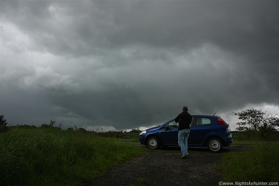 |
A quick break in the tense excitement showing Declan in action. He was getting worked up because one of the legs on his tripod had broken and he was trying to get it fixed while searching the ground for an important metal component, he was missing out on the c-g action and rotation trying to get it all fixed as he wanted to get his video camera mounted on the tripod. Meanwhile the hail got heavier and the S cell behind us was getting close so we would soon be taking cover. The area of interest is directly opposite Declan's head with precip core and lightning to the L and rotating inflow straight ahead. Declan eventually got his tripod fixed, his old VHS video camera was attached, and he was back in business and in good time too because look what happened next.
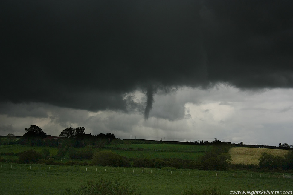 |
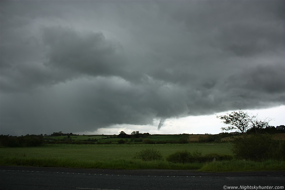
Suddenly at 15.00 BST the rapid rotation under the updraught base tightened and the surrounding inflow scud wrapped up to form a very obvious funnel cloud, at first it looked like a black cigar suspended in a vertical position then it began changing shape literally by the sec. I realised my video camera was pointing in the wrong direction so I quickly ran back to the car and twisted it to face the funnel and let it record the event at wide angle then I ran back to my location at the road side and began taking still images one after the other. The black storm clouds and black funnel looked amazing over the lush green fields, this image is at 55mm so you can see that this was quite large and not that far away from us. Note the time - 15.00 - exactly what we predicted earlier in the day!.
 |
I quickly went back to 18mm wide angle which makes things look smaller and further away than they actually are however it has the added benefit of showing the funnel along with its parent storm structure all at the same time which is exactly what I wanted. This was looking NE from the carriageway towards the Knockloughrim area not far from Maghera. The funnel consisted of two intertwining vortices which wrapped around each other as they twisted in unison.
 |
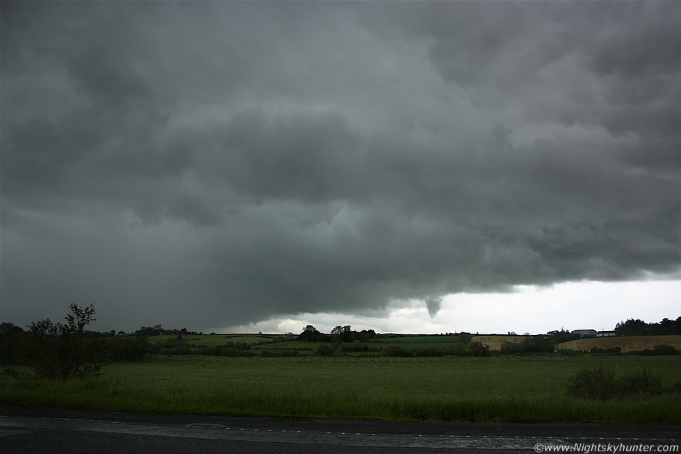
The two vortices then tightened and blended into a single form and lowered towards the ground while spinning rapidly. Declan was taking fantastic video footage at this stage while the both of us documented the funnel with still images, it can be difficult to concentrate on photography when a funnel appears because the sudden excitement can cause you to freeze or else you can't decide whether to watch the show or concentrate on taking images and with everything moving so fast and changing shape by the sec it can be difficult to get the correct exposure for a hand held shot in very low light levels so the pressure is always on. My approach was to watch the scene through the viewfinder while snapping images at various focal lengths while making small adjustments to the shutter speed and aperture in manual mode which worked out quite well.
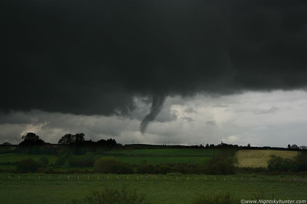 |
This was the most photogenic moment of the day when the funnel reached it's peak while spinning and changing shape into a graceful bend while reaching for the fields below and flirting with the ground, at this stage it was so low we considered the possibility that this could be a brief tornado because the full invisible vortex is wider and longer than the actual size of the visible condensation funnel, this is why all decent funnel clouds should be investigated incase there was a touch down. While this scene unfolded there where blue c-gs striking the fields within the precip core to the LHS, loud thunder, and big hail stones hitting the ground around us, it felt surreal to say the least. This was again at 55mm using the Canon 18-55mm IS lens, I could have got in closer as my 100-400mm IS USM lens was in the car however I didn't want to risk missing any of the action changing lenses, this proved to be a good decision. The cloud collar directly above the funnel was rotating as well, I could discern slight horizontal motion of the funnel from L to R along with it's anti-clockwise rotation.
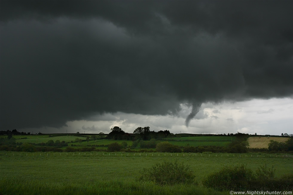 |
Now backing out to 35mm to get storm structure and funnel in the same frame, this is by far my favourite image from the day due to the photogenic nature of the entire scene, imagine the funnel spinning, changing shape, rotating cloud base above, blue lightning to the L, thunder and hail and you can imagine what it was like to witness this in the flesh at the time. You can't get much closer to getting a tornado than this!
 |
I was glad I concentrated on those images when I did as sec's later the funnel yet again changed shape, straightened up, then slanted towards the precip core. The top portion of the funnel seemed to have less condensation so it appeared more transparent however the bottom of the funnel was still visible and rotating. The intensity of the vortex seemed to relax a little and the funnel vanished leaving behind hanging segments of scud which were still rotating, we could tell it wasn't done yet and was ready for another round so we didn't let our guard down for a moment.
 |
As expected the funnel reformed, this time as a broad cone which developed good rotation before eventually dissipitating, the entire funnel had been visible for 5 min's or more and all the time accompanied by periodic thunder and intense hail.
Here's a video clip I made showing some of the structure on the updraught base along with wide angle footage of the funnel cloud at it's most impressive stage.
This is Declan's stunning zoomed-in high quality video footage showing most of the funnel's life time, this is followed by a x4 speed time lapse segment which shows the rotation extremely well.
When the funnel vanished we got battered by nasty outflow from the multicell line in the form of torrential rain and big hail stones, at this stage the line of storms was showing persistent red and white echoes on radar which are at the very top of the scale indicating a very strong storm. So much hail fell from this storm that the roads had a blanket of white giving the impression of snow, my Dad later informed me that the hail was so bad outside Magherafelt that he thought his windscreen was going to come through. Declan and I chased after the area of rotation while the storm gave us hell on the country roads around Lavy, however the rotating area was gone but we could make out a big gust front with whale's mouth miles away to the E. We drove back to the country roads in Maghera and watched the lightning which was a good mix of c-g and I-c, some of the bolts where so close they struck the fields in front of us and others flashed directly overhead and came close to striking the car with shotgun thunder, it was too dangerous to be outside so we stayed in the car until it passed. The storm continued moving E producing lightning for several hours and after a second chase we decided to let it go after 16.15 BST and headed home. It had been an amazing day, we had been trying for years to get a good funnel and today was the day when all the effort finally paid off, it was worth the wait!.
The following day, June 8th, a damaging tornado hit a farm in Eglinton, Co. Derry not that far from our area, the tornado ripped the roof off a barn and knocked a wall onto a car destroying it in the process while ten terrified farm workers looked on as the tornado tore through the fields, this was the first tornado in N. Ireland since 2007. On June 9th Declan and I did a site investigation of our own funnel, we returned to our watch point and navigated around the country roads, I have a fond memory of sitting on the car roof to scan the fields over the tall edges looking for damage while Declan used his video clip to locate frames of reference in the area such as telegraph poles, houses, barns, and fields, all while the evening sun shone brightly on us while the Sperrin Mountains begged for attention below. We knocked on a number of doors looking for witnesses and found three more who saw the funnel which helped us narrow down exactly where it was rotating. The funnel was over several fields very close to, and W of the Knockloughrim Road and since there was no damage we can put this one to rest as a funnel cloud. I saw another funnel on June 10th and another spotter saw two more that same evening so that makes 5 funnel clouds and 1 tornado in N. Ireland within 5 days!. 2011 is fast becoming a great year for sky events, a year of quality rather than quantity so who knows what's going to happen next. In the meantime you can check out Declan's image report here. Thanks for reading.