

|
|
This turned out to be a spectacular day for Autumn thunderstorms across many parts of Ireland and N. Ireland. In a nut shell there was 500-600 CAPE, LI's -2, very good lapse rates, enough moisture, an abundance of clear skies with more than sufficient solar heating, cool air aloft between -20 and -30 degrees C, and most important of all was the presence of strong vertical wind shear which meant any storms could be very well organised posing a risk of isolated severe weather. Wind shear causes the main updraught of a cell to lean forward so the inflow and outflow is separated which means a storm can last much longer and grow more intense with a greater risk of large hail, convective gusts, and even funnel clouds and tornadoes.
Things kicked off in spectacular fashion by mid morning, the radar showed an active storm which moved inland from the Atlantic Ocean over W. Ireland which began moving slowly NE, the sferics charts showed active c-g rates as the storm advanced towards the N. Ireland border, I had my eye on this and wondered if it would sustain itself long enough to make it further N, in any case it would take a while to get here so I did a visual check on the sky. An impressive Cb with large anvil and mammatus was sailing across the mountains to my W like a majestic Ocean vessel so I decided to chase after it to pass the time. I positioned myself on the Glenshane Pass and watched as the base of the updraught produced a lowering which began slowly rotating while large mammatus bags formed on the rear of the anvil and for a few exciting min's I thought I was going to get a funnel from it however it just rotated then vanished over the Sperrins. I was still quite impressed by what I had seen for so early in the day.
I went for a walk around Glenshane to get some fresh air then slowly drove down to lower ground, it was now early afternoon. I got a text message from chaser Paul Martin, he had been watching those southern storms too and said they where crossing the border over Fermanagh heading NE, I instinctively glanced to the SW once I cleared the hills - NO WAY, I couldn't believe it, I could actually see the enormous anvil on that storm over Co. Fermanagh all the way from outside Maghera, that's a considerable distance to say the least and the visual appearance of the anvil was outstanding, it was obvious that this storm was strong and as I watched I could see the anvil getting bigger and bigger which meant it was heading my way. At this point I began to get very excited as this was no ordinary thundery shower, this was the same storm I saw on the radar during the morning and it was still going strong for hours as it trekked across the country so it was an organised cell which was taking full advantage of the wind shear. I needed to see the online situation for myself so I drove back home to form a plan.
I had a feeling I was going to be leaving in a hurry once I checked the computer so I made a priority of making a quick lunch and a brew to top up my energy. My toast and mug of tea were gone in a few min's because I couldn't wait any longer, another brief look out the window and I could see the anvil getting bigger in the sky, I was quite shocked by the size of it in relation to it's distance, I wondered how fast it was moving, I didn't want to get fooled into leaving early only to be sitting for hours watching an anvil over the horizon with no hope of an intercept, on the other hand it did look to be gaining ground very quickly and if this was the case I would need to be getting on the road asap. The computer gave the answer, the radar was down so I couldn't see the precip rates and didn't know it's exact position, this was absolutely typical, it works all year when there's nothing good happening then when I need it most the thing is down and frozen at 12.30, it was now around 14.30 and I felt blind. Checked the sferics - pure eye candy!, a huge line of constant c-g lightning extending all the way from the Republic, across the border, and moving NE towards the S of Lough Neagh. Sat 24 got my adrenaline pumping even further as the anvil was huge and almost at the Lough Neagh basin already!. There was no way I was going to wait here for it to arrive so I decided to give chase, I took my Dog 'Drew' with me as he was chasing after me when I left the house, he's just mad about going for a drive in the car so I took him with me. The problem was that he is petrified of thunder so he would just have to take the good with the bad today.
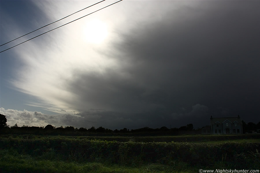 |
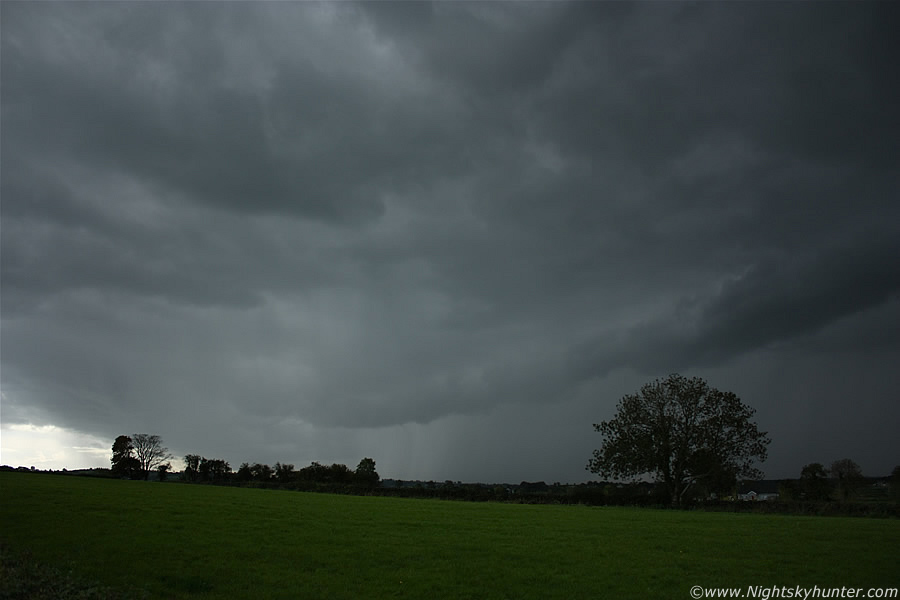
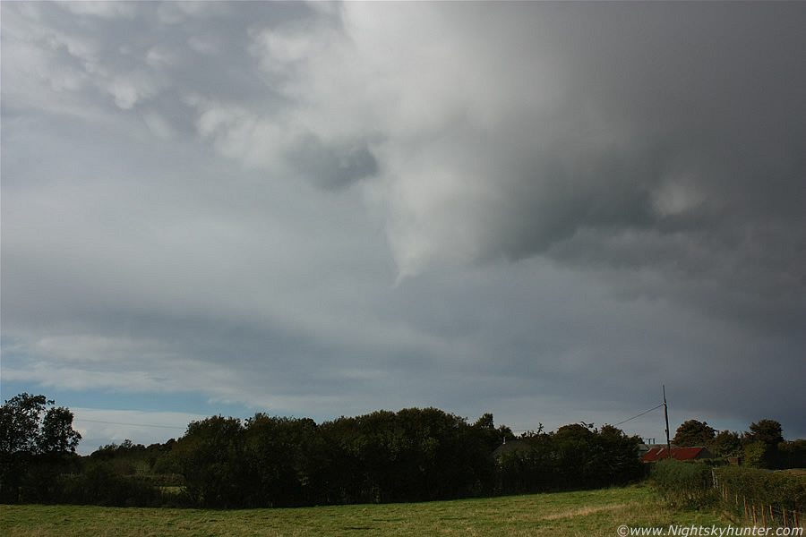
My plan was simple - drive S as far as I could as quickly as I could. Once I got off the main road into the country I was driving at a very rapid pace indeed, the sky to my SW was turning extremely dark and the storm's anvil was sheared downwind for tens of miles and gradually turning the sky overcast. I pulled over for a very quick snap from the country between the Castledawson roundabout and Ballyronan, I was just leaning out the driver's window for this image before I moved on, shame about those blasted power lines. The image is self explanatory, the base of the storm itself is not even in view yet and still tens of miles away spitting regular c-g bolts across the country as it advanced, ahead of it is the huge anvil. If you are ever in doubt about storm is motion just look at the direction the anvil is blowing, that will tell you in what direction the cell is moving as the anvil will usually precede the storm itself due to the strong upper winds blowing the incus canopy of cirrus and ice crystals downrange. The outer anvil looks very tenuous here, that usually is a sign of a weak updraught and hence weak storm however in this case that rule doesn't apply because this storm was constantly regenerating, by this I mean new updraughts and new anvils will form to replace the old ones. I should have stayed longer for a better image but time was pressing and I needed to keep moving as the stronger precip under this storm was further S and that's where I wanted to be.
 |
Here's the visual satellite image from Sat 24, my approximate location is shown by the red 'X' which is to the L (W) of the Lough Neagh basin. You can see that the storm itself is very close to my SW with several embedded cells, it's moving NE and about to pass over me, the storm is almost the vertical length of N. Ireland itself with flanking area below the border and northern tip of the anvil near the N coast at Portrush. At one stage this storm had two overshooting tops which meant that on two occasions the storm updraught had rose higher than the anvil at the top of the Troposphere and punched into the lower Stratosphere. Overshooting tops can be a sign of a severe storm with an increased chance of tornado activity. Interestingly there is a smaller overshooter on this image which is very close to me.
I put my foot down and navigated through the country roads with purpose, Drew was enjoying himself in the back seat occasionally glancing out the window to see where he was while I kept flicking my gaze from road to sky and back again over and over, the view of the storm was getting so interesting that it stole my attention so I switched off the radio in the hope of hearing thunder because it was obvious that the storm had to be booming away as I watched. Normally I'm obsessed with detail, by that I mean that I like to know in advance where my destination was because that way I know how to get there and what the foreground was like in relation to compass points, today was different, I was just driving S with no destination in mind and I didn't care where I ended up, it was just me and the storm, this freedom felt fantastic, refreshing, and liberating so I just kept going. I passed through Ballyronan and headed S through deep countryside with the beautiful blue water of the Lough to my L, I thought about Ardboe but decided against it so went in the rough direction of Coalisland, now I wasn't choosing roads based on maps, I just picking the option which brought me closer to and ahead of the storm. I came to a junction with three options, I choose the centre and drove straight on into unknown territory, I was really enjoying this adventure. I entered Coagh and navigated through the roads near homes which seemed to have cars parked everywhere on both sides of the road which involved weaving around obstacles then I made it back into the countryside still going S into no man's land.
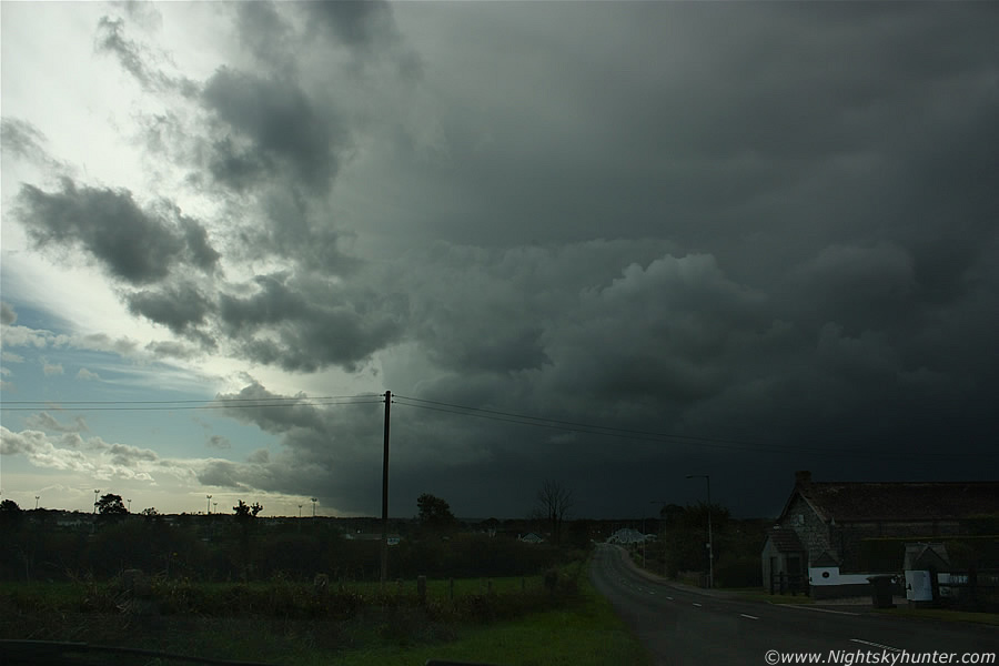 |
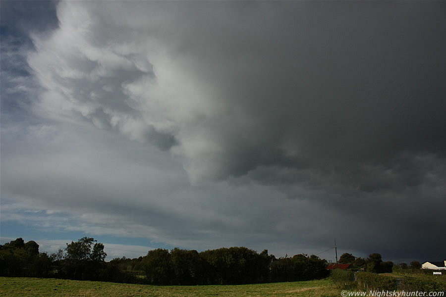
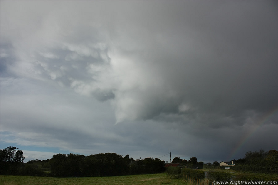
I was making good progress until I got stuck behind another driver who very quickly began to get on my nerves, I'm not joking when I say this, the car was doing 30mph on an open country road, I checked this against my own speedometer, I couldn't believe how slow here was going, it was unreal, and to make matters worse this wasn't a small transient moment in his life of driving slow, he was doing it for miles and no doubt was doing the same before I caught up with him. There were no R or L plates on the windows and the driver was neither young or old so I couldn't understand the logic behind such a slow speed. I couldn't pass him due to oncoming traffic so I had to tail him while trying to avoid the temptation to hit the horn, eventually we moved onto a straight road with no traffic so I overtook him, I was thankful to be back at my own pace again. The storm looked menacing so I quickly pulled over for a very quick shot, there where no options and the traffic was light so I stopped at a junction to the L of the road and half mounted the grass verge, this is from where I took the above image. So there I was outside Coagh looking directly out the car windscreen at this massive storm, you can see how dark and intense the precip area is underneath the cell, it's moving R to L and towards me at the same time.
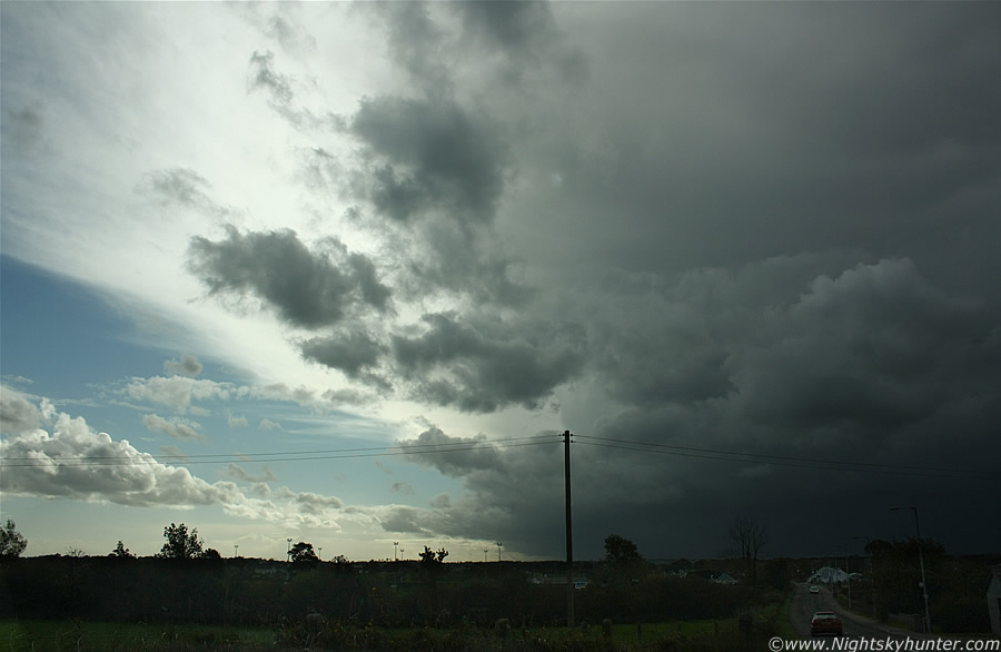 |
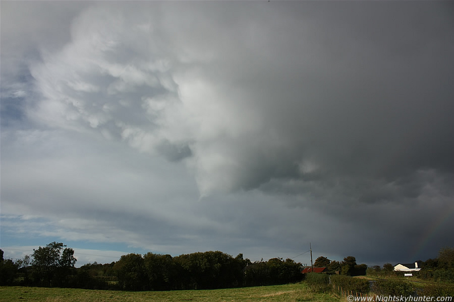
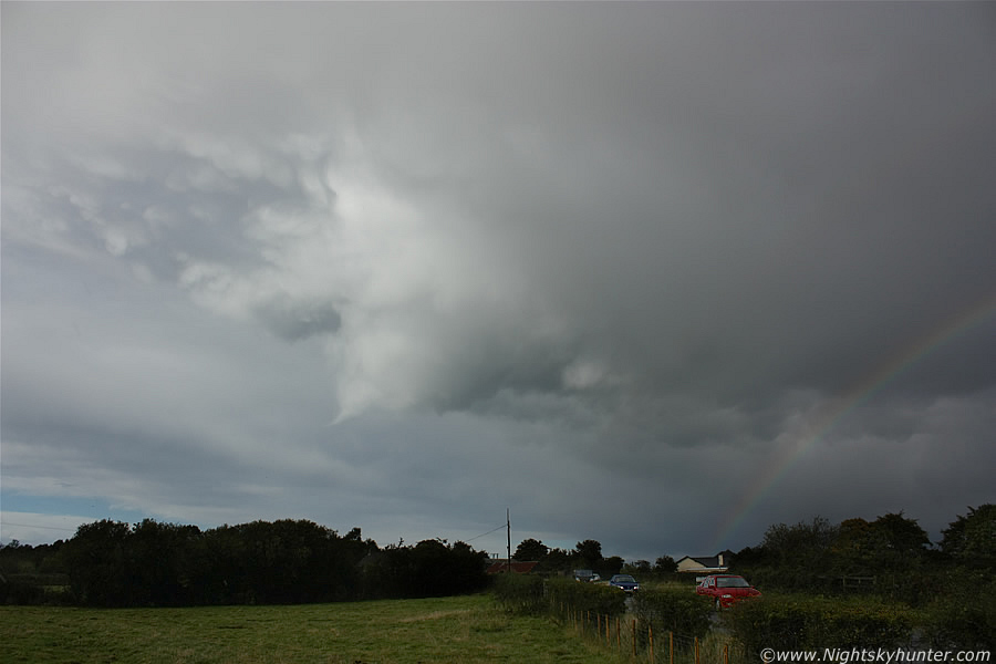
Same scene with the camera panned to the L to show more of the big anvil shield, and yes the sky really was that dark, this was around 15.00 BST. This image and one above were taken at the approx time when a bolt of lightning struck a house in Newry, Co. Down causing considerable damage. The c-g blew a hole in the roof, smashed windows, exploded electrical sockets, and even moved a 4x4 jeep with it's driver inside it at the time, the story was sufficiently serious enough to make it onto the news that evening. I suspect this could have been a positive bolt, the eyewitness on television described the hail as ''like golf balls'', so perhaps this was a borderline severe storm for intervals of its long life. At this moment in time it had been producing lightning for hours with no intention of stopping, without a doubt this was the best Autumn thunderstorm I had encountered to date. You see the road on the image to the lower R?, I headed down that out to the country again and the storm raced in surprisingly quickly filling my windscreen.
 |
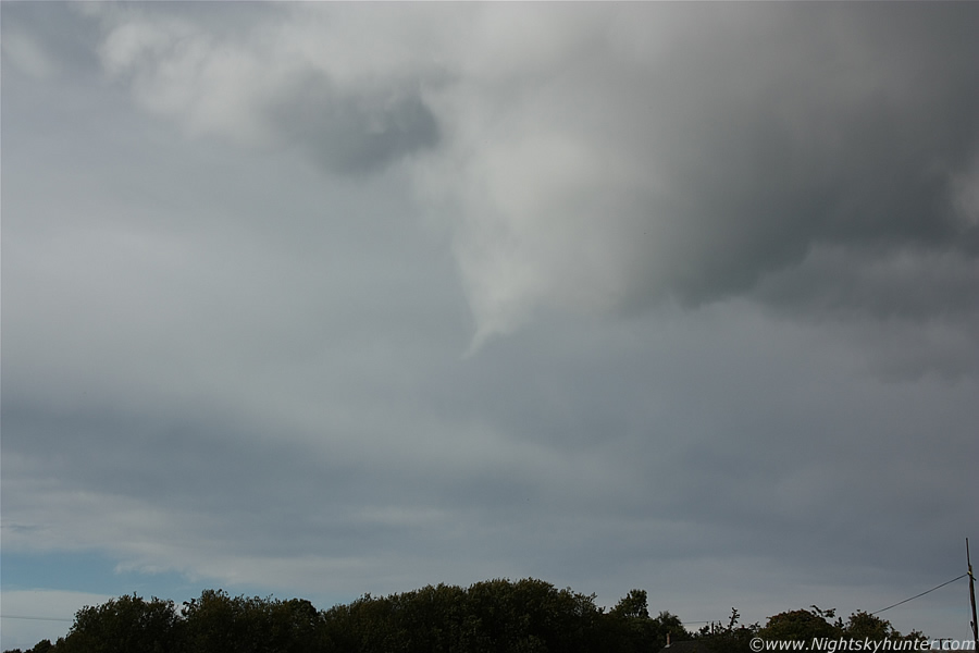
The chasing was over, the storm was here so I needed to stop as there was no point driving on wasting fuel, I was still located far outside Coagh on the main road to Stewartstown, I saw a narrow gap in the hedges which was a short lane which merged into a farmer's field so I reversed in there and parked up to watch the storm. It wasn't a good spot as I had a tall hedge on either side of me blocking the view but I was glad to have stopped anyway so I could relax. I had to stand on top of gate while balancing precariously to see over the hedge and take this image. That's the gust front on the leading edge of the storm, the feature was young and not fully developed yet so I didn't get rewarded with any structure shots this time, however you can appreciate the menacing dark thundery sky and heavy precip behind the guster moving towards me.
The temperature dropped like a stone, a cool wind picked up and large precip drops began to fall, then boooooommmmm!, a loud crack of thunder ripped through he sky, I got back in the car to take shelter as I was at risk of getting hit. Drew began panting like mad completely terrified of the thunder, he had squeezed himself down into the foot well behind the driver's seat and was shaking like a leaf so I spent some time comforting him and talking in a gentle voice which worked until the sky lit up white with another flash of lightning followed by a roaring rumble of thunder which was actually pretty darn scary to be honest, Drew wasn't having any of my comforting chat and quite rightly didn't believe a word I was telling him so he had to put up with it. I missed those strikes and rumbles on video however I did catch a couple soon after which don't do them justice at all. It was raining heavily and I got three more loud rumbles while the fields and windows illuminated intensely for a fraction of a sec each time a bolt hit, I never did see them directly though. I was very happy at this point because I had achieved my goal of intercepting a storm, and it had went perfectly so anything else was just icing on the convective cake.
I got back on the road again and followed the storm N under dark skies and heavy rain with full headlights on and adrenalin pumping then the rain got so bad that I pulled over again, I just took the first narrow lane to the my R and drove down into the middle of nowhere then stopped at a gate and waited. Then I got hit by a complete deluge from the storm which was extremely nasty, very intense rain, hail and gusty winds lashed the windows which sounded like hundreds of nails from unseen hands scratching at the glass as the car gently rocked on its suspension, this really was a significant core!, the last two rumbles of thunder let rip as the crescendo reached it's peak. There was a van parked in the lane beside me taking shelter from the storm, the occupants wondered what I was doing parked there, then they saw the video camera pointing out the window towards the storm lol, I wondered what they were thinking. The storm passed through so I drove back onto the main road in pursuit. I retraced the roads again and had the rear of the storm in view the entire time as I drove N, I drove back through Coagh, through Ballyronan, then a clearance arrived from the W with blue sky and a much welcome Sun. The main core of the storm was now heading for Antrim, I was contemplating my next move when I spotted a nice cluster of mammatus forming under the storm's anvil so I pulled over yet again to get a few images.
 |
Parked on the roadside somewhere between Ballyronan and the road to Toome looking N to NE just before 16.00 BST. The white mammatus under the anvil looked pretty good so I began taking images at a relaxed pace while soaking up the warm sunshine, then suddenly things began to get very interesting indeed. This large cloud collar suddenly developed and began rotating in a very obvious fashion, this was a vortex forming and the precursor to a funnel or tornado.
 |
Then a beautiful white-coloured needle-like funnel cloud extended out from the snout of the cloud collar, I couldn't believe my luck, and to top it all off there was mammatus visible to either side of the funnel with a primary and secondary rainbow to the R, at this moment in time I was stunned, I had never seen all three phenomena before at the same time so this was an absolute visual treat. I was no longer relaxed, my adrenaline was pumping again and my rate of shooting increased dramatically. The storm was moving to the R and away from me but at a very slow pace so the funnel seemed like it was just hanging stationary over that field.
 |
These first set are all 18mm wide angle so you can appreciate that the subject is taking up a large area of sky so the mammatus and cloud collar were quite substantial in size. The funnel was very well defined, clearly rotating, and continued to do so for approx 5 min's. Judging by the angle of the collar and funnel the updraught from which they developed must have been tilted over quite strongly in the shear.
 |
This was at 27mm, the funnel is small and thin however the cloud collar was quite strong looking, I was thinking that had there been greater CAPE today then perhaps this may have touched down, after all it's not that far above the ground at all. Shooting it was not straight forward due to the bright Sun so getting a decent exposure wasn't easy.
 |
Happy days - mammatus, funnel cloud, and double rainbow all in the same frame. This was honestly the last thing I was expecting today, this scene was even more unusual as mammatus usually form when a storm is weakening (unless it's severe) yet here are the mammatus in conjunction with a strong enough updraught to produce a funnel. You can see the affects of wind shear in the image due to the wide separation of inflow/outflow. The bow had formed on the back edge of the precip core to the far R with plenty of room for the cell to breath behind it where the funnel was located. The weird thing is that you can actually see mammatus pouches wrapped around the collar.
 |
I was very fortunate to have been located at the back edge of the storm at this stage, this is where chasers want to be on any storm because funnels and tornadoes are more likely to form under the updraught/inflow area/ RFB or flanking line, although on occasion you can get them on a gust front too. Had I stayed back in Coagh for 5 min's longer I would have completely missed this, it's amazing how a few min's can mean the difference between seeing something spectacular and nothing at all. There where plenty of cars on this road yet I doubt any of the occupants noticed the funnel, certainly none of them pulled over for a look anyway. I can't tell you how thrilled I was at this point, my hands were actually shaking slightly, I have seen many funnels over the years however that special feeling never gets subdued when I see another, it was like Christmas morning all over again!.
 |
Zoomed in at 41mm, then the funnel developed a marked bend which gave it a hook-like shape then it fizzled out. I can only imagine how amazing the photogenic potential of this scene could have been if the background sky had been clear and blue. The mammatus then intensified and the anvil shredded to pieces leaving a ragged orphan behind with a full rainbow piercing the scene while the Sun transformed the soaking roads into bright happy colours and within min's you wouldn't have known there had been a storm and funnel cloud here. This was the 6th funnel cloud I have observed during 2010 and the most photogenic so far.
After this I drove home on a complete high with with Sheryl Crow's ''All I Want To Do Is Have Some Fun'' playing loud on the radio so I really couldn't have asked for a more fun and thrilling day. Then to my W in the low afternoon Sun I saw an amazing cell against the blue sky with a huge sheared anvil blowing across the W to NW skyline with a large overshooting top shaped like a white dome with solid vertical rear edge and strong back building towers feeding into the updraught, it looked incredible and must have been of huge size to have been seen from this distance, I suspect it was over the W coast. I noticed my fuel level was extremely low and actually near the bottom of the reserve almost touching the red line at the bottom and I began to panic, I was driving through Magherafelt onto the carriageway back home sucking on fumes, I had no money with me and no credit on my phone so I could do nothing but cross my fingers and hope I made it home in time. If I ran out I would have to wait at the road side until I was missed then someone would ring me, fortunately I made it home and the tank wasn't as low as I thought due to the fuel gauge giving different readings and getting stuck, that was a relief.
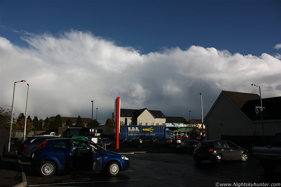 |
Late afternoon in Maghera looking E towards Co. Antrim from a local shopping center car park. That's my old line of storms, however new cells rapidly developed and grew into several more strong storms, several anvils were on view, bright hail curtains, bow segments, mammatus, and the biggest pileus cap I have ever seen covering the entire updraught of the storm (not photographed), it was approx 20 degrees long and was far into the E on the other side of Lough Neagh. I got a text from Louise Magill reporting regular thunder from this storm over Randalstown, it was the second storm there that day and the best of the year in that area. A while after this Conor McDonald rang me, he was coming home through Antrim and could see the front of that storm, he informed me that the gust front was stunning with teeth very low to the ground and similar in standard to what he had seen in Australia!. That's quite an exciting report because Conor doesn't get easily excited by storms unless something very significant is happening. I really wish I had seen that gust front. This turned out to be a very active day, those storms traveled all the way from the Republic, across the border, then moved NE through all of N. Ireland where several crossed the Ocean and hit the W side of Scotland, there was regular c-g lightning the entire time!.
Video clip from the action, this isn't a very good clip and the camera work is very shaky, it shows the storm hitting with the precip core and gusty winds along with two loud rumbles of thunder, if you listen carefully you can even hear Drew panting in the back seat, then followed by a few stills of the funnel. Until the next chase, thanks very much for reading.
Martin McKenna