
What an evening this turned out to be!. First of all, let's back track to the early morning hours of April 25th at 01.00 BST. I was on the phone to Astronomer John McConnell, our conversation was focused on the weather though. We where both online watching the Met Office radar and infra red sat images studying the storms which where located over SW UK. The region on the coast itself , and out to Sea, over the Lands End area in Cornwall, was getting some battering from a large storm producing torrential rain, strong wind, and lightning. From the movement of the rain band and frontal system we speculated that there would be a chance of thunderstorms over N. Ireland during the afternoon. I learned the next day that the S UK storm had killed several people when their car got washed away down a river due to a flash flood. A sad incident indeed.
I was up early on the 25th because I suspected something was going to fire off in NI so I logged onto the net and was delighted to see that an official convective forecast had been issued by Tony Gilbert (TORRO) from the UKweatherworld. The forecast was for a slight risk of general thundery showers over NI which were expected to develop late in the period. The main ingredient was solar heating, if the Sun could break out and heat the ground then there was a good chance of t-storms somewhere. By late morning the grey frontal cloud had gone and the Sun was out in force. In fact, it was quite hot with intense sunshine, and it stayed that way for a long time. I immediately had a good feeling. By the early afternoon I was looking at the radar again, nothing exciting at all, I was beginning to have my doubts until I glanced out my window to the E and seen serious convection arriving from that direction, in what seemed like min's. This was elevated convection known as Altocumulus Castellanus which indicate instability at mid levels of the atmosphere. They are usually an indication that storms will form later in the day. In the UK these are most often seen prior to a plume type event when warm moist air is advected up from the continent which can produce incredible night time t-storms across much of the UK. The last good displays I seen were during the big 2005 and 2006 storm years.
Some people describe these Castellanus clouds as being similar to castle turrets. Imagine a normal mid level (Alto) Cumulus cloud like Altocumulus, the difference is that the Castellanus species have advanced vertical growth, they look like low level convection with their bases much higher in the sky. Well, the Castellanus I seen on this day were the very best I have ever seen in my life. The clouds had huge updraughts/towers which were erupting with energy. At one time there would be as many as three towers going up from a single base, and when I say going up, I mean going up!. These clouds expanded and rose in height each sec. I recall watching on Cumulus which turned onto a Towering Cumulus in what seemed like sec's, then it would develop a sudden mushroom shape and flatten out into a Cumulonimbus Anvil. The heat was invigorating these in a big way. The base were very dark with back scud hanging down to low levels, which when combined with the hazy sunshine, and sun beams stabbing through the clouds, they had thunder written all over them. I really thought the sky was going to explode at any moment. The best example I seen was to the S of Maghera over Slieve Gallion where it seemed to sit for a long time. This was a serious convective cell of huge size, I was impressed beyond words and was beside myself was excitement. It looked similar to the awesome convection I had seen during the Summer of 2007 when we had nasty t-storms here. I never thought I would see something like that again so soon. I put a few excited reports on several weather forums and soon others across NI where getting the same convection.
Why do I have no images of these?. My batteries where on the charger so I let them stay there. During a previous convective outing durng April I lost my back-up set of rechargeable batteries when imaging a Shelf Cloud which passed over. I have never found them since. They are obviously lost in a field somewhere. For this reason I had to restrain myself and keep the batteries in the charger incase more serious action developed later in the day. So, I just watched the convection and used it to gain new knowledge. When I was in the town of Maghera one of these Castellanus bases produced a brief but intense shower of rain and hail stones over the town. I couldn't wait to get home and grab my camera because lightning felt close by. Back at home a line of big Cumulonimbus cells formed over the N Sperrins so I went out to take images. The sky at this time was not photogenic because the cells were obscured by haze/murk combined with intense sunlight which made the anvil top blaze in high contrast to the dark bottom. The cells produced nothing and it was back to getting sunburn. The sky was drying up and showing more blue than cloud, so it looked like the potential was over. I went back home feeling let down, had dinner, and went back on the net to see what was happening.
When I looked at the radar I had instant tunnel vision when I seen strong echoes. T-storms had moved into the NE coast line, however a more dramatic scene was unfolding over the NE side of Lough Neagh. Red and white echoes showed that serious rainfall was occurring there, I clicked on the sferics and got the confirmation I needed, there was a storm for certain, it was producing alot of lightning and was moving slowly to the SW. I watched it for a long time and was certain this was the main storm of interest occurring in the country on the day. Then the reports came in, thunder, lightning, torrential rain, local flooding, however the most remarkable report was from Co. Antrim which went like this, and I quote...''Omg omg omg sorry attention everyone, we are just having golf ball size hail, heavy rain, thunder, lightning, flooding, high winds''. When I heard that report I almost fell off my computer chair. I said a few choice words out loud which I will not repeat and told everyone else at home what was happening. Hail stones the size of GOLF BALLS, that does not happen very often in the UK. To get hail that size you would need a very powerful updraught within the cell with enough wind shear to keep it organized for a long time. In other words, garden variety thunderstorms do not produce hail that size so this was an exceptional event. I immediately suspected this was no ordinary cell. With another look on the radar I could still see this cell, it was moving further SW, still over Antrim, but getting closer to Lough Neagh. If it kept on its current track then I suspected it could be seen from the opposite (NW) shore of the Lough. So, a quick plan was created and a family member and I decided we would drive out to Ballyronan Marina on the NW shore of the Lough, and if we were very lucky the cell might be within visual range. It had already been producing lightning for several hours so I thought it would no doubt be dead by the time we got there. If I could just see something of it, then I would be happy.
Then came surprise number two. We had just got into the car and pulled out onto the main road, this was in Maghera by the way, I looked to the E and I couldn't believe what I saw. This cell, with it's base over Co. Antrim, was clearly visible from Maghera, my home!!!. It was a monster, I could see the tall white anvil taking up a large area of the sky. The base was that far away that it couldn't be seen. As we drove down the main road heading in that direction we could see the cell through the front windscreen the entire time. Very slowly it got larger and larger as we got closer, when in Magherafelt it took up a large section of the sky. I couldn't wait to see what was below.
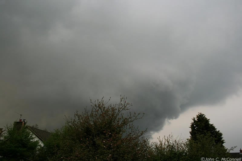 |
Meanwhile, and unknown to me at this time, several photographers where out taking images of this cell. Greg Lloyd and John C. McConnell, both from Maghaberry, had just taken a selection of great images of the most important part of this cell. If these images had not been taken then there would have been little in the way of speculation into the nature of this cell. I can't put all the images up here so I have chosen just one, because one is all that's needed. This one is from John McConnell. This huge lowering was taken with a wide angle 18mm lens so you can appreciate how large and close it was at the time. This is the all important updraught/inflow region of the storm. This lowering is actually a Wall Cloud. To anyone who knows their storm structures well, you will immediately notice the sculptured structure on the R of the lowering with horizontal ridges going across the top of the Wall Cloud. This pattern is a visual sign that the updraught is rotating and contains a Mesocyclone inside. All of the images taken by both Greg and John, show this feature very well. Furthermore, some of the images sport a notable green colour which is an indication of large hail suspended within the cell. This colour is most often seen in severe t-storms in the US and other parts of the world. At the time of writing I received a report via email from an observer in the area who said that the storm passed over his home TWICE, and that he was convinced it was rotating. Considering the golf ball sized hail, which already classifies it as a severe storm, combined with the long life of the storm, the severe weather it produced, and the images of the suspect Meso, I feel confident in speculating that this storm is a good candidate for a HP Supercell, this is also a rare sight in the UK!. Another observer from Co. Armagh said it was the worst thunderstorm he had seen in years, outside the main Summer period. Steven Hooks from Co. Armagh took some great images showing the menacing Shelf Cloud on the leading edge of the storm as it approached his area.
I was unaware of all the above as we drove through twisting country roads outside Ballyronan. I was thinking about that giant hail and the possible Supercell connection. The roads had been bone dry throughout our journey until we approached the junction in Ballyronan. Here the roads were soaken from an obvious deluge which had taken place earlier, I glanced out the passenger window and managed to see two hail stones, the rest must have melted but these two were the largest I have ever seen before, at first I thought they were white rocks until I had a closer look. The two hail stones were eroded by the Sun, but even so, they were not far off the golf ball size. This confirmed the large hail report earlier. Pity I didn't get up there sooner because I may have had the whole lot bouncing off the roof of the car. That would have been a cool video clip to have!. I couldn't get any images because it was a main road but it was not a priority because I could now see the huge black base of this storm over the Lough itself!.
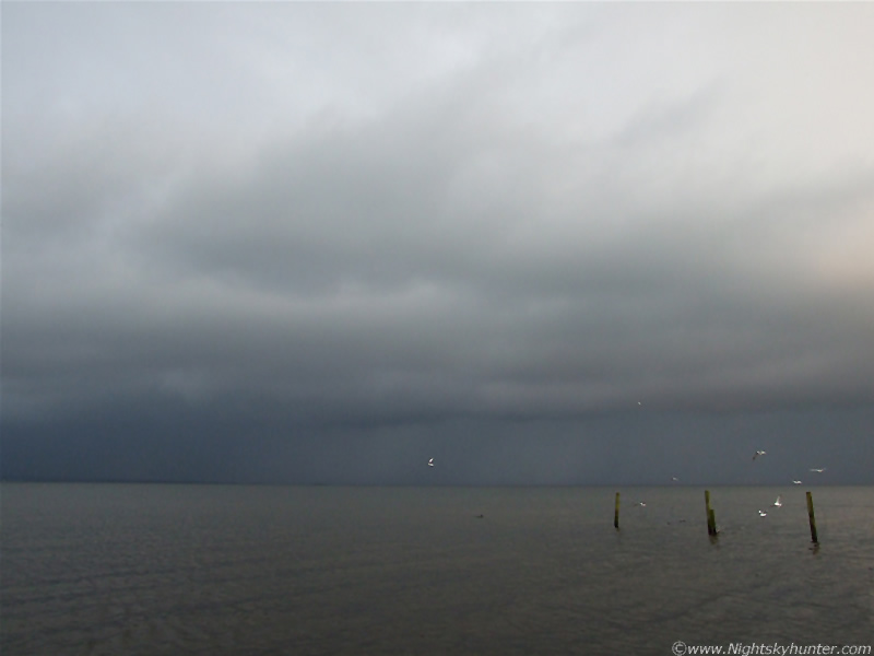
There where only a few cars in the car park on the Lough shore at the Marina, the area had a feeling that it had been abandoned earlier, presumably due to the storm. A few people sat in their cars and watched it from the safety of inside. I quickly got the camera and tripod set up on the sandy shore and began to take images. The storm was clearly outflow dominant and long past it's most mature stage but it was still an impressive sight and putting on a good show. The base took up the entire length of the Lough over that area and was hugging very close to the water. The anvil could not be seen from so close a range, it was well out of view high up in the atmosphere. This cell was so large, that the storm structure you seen, was entirely dependant on your geographical location. I could not see the updraught at all, I was on the wrong side of the storm for that, but I was looking at the outflow region of the cell.
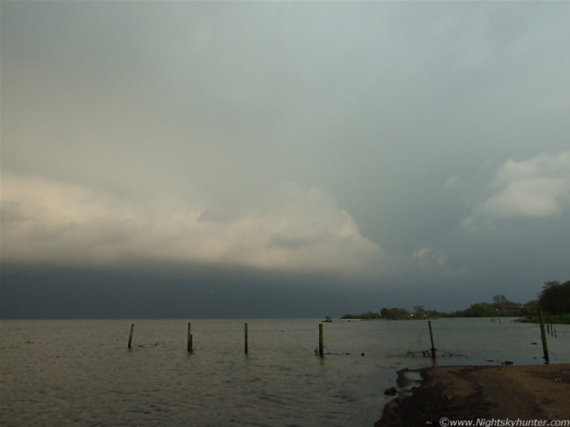 |
The only structure visible was the Shelf Cloud, here I'm viewing it side-on as the cell slowly moved to the R (SW). The Shelf stretched across much of the Lough and was clearly curving around the R leading edge. The view of it must have been great further to the SW. I could even see solid looking teeth under the Shelf which looked really cool. Below the Shelf was the precip curtain. This was a nasty looking area, the rain looked dark and evil with well defined vertical striation lines through the curtains. The curtain had a subtle dark green colour further to the L (NE) where hail must have been still falling on the E Lough shore. The Sun was getting low at the time and casting a strange soft colour onto the Shelf. I should take this opportunity to apologize for the poor images I have of this big storm. I made such an amateur mistake, I was so excited and in such a hurry to get images that I had my camera on ISO400 instead of ISO100. Big mistake. I wasn't aware of this at the time but I do recall thinking it was strange that I had to use such fast shutter speeds which was odd. The images looked grainy on the LCD screen but I couldn't figure out why. It was only when I uploaded the images later that I became aware of my mistake. As a result all of the images are extremely noisy/grainy and quite horrible to look at. I used the 'despeckle' mode in Photo Elements which worked to some extent, however it did make the images extremely soft. There's nothing I can do about it now other than include a few images for the sake of the record. Lessons have been learned, it was a storm chasing success, but a photographic failure.
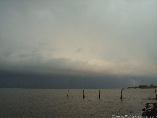 |
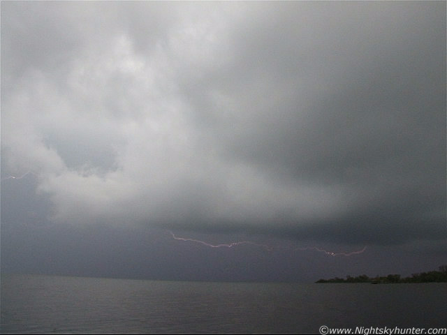
It was such a surreal atmosphere here on the Lough shore. Despite a periodic gentle breeze it mostly calm and quiet. The back ground noise was the sound of Ducks and the water gently splashing against rocks mixed with the low rumbling sound of distant thunder booming across the water. The first c-g I spotted was a lovely blue colour with multiple branches. It hit the water, then a long silence followed, then the rumble would arrive so it must have been a few miles away. The bolts arrived from the leading edge of Shelf to the far R so there where to active areas which were electrical. I heard quite alot of thunder and seen more than my share of lightning. I have always wanted to see lightning over Lough Neagh and this evening I got what I wanted so I was in heaven. Above is a video still showing another c-g under the Shelf.
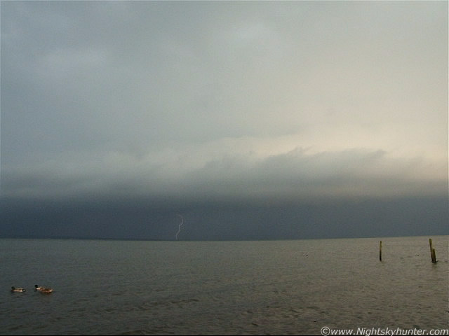 |
Here's another from the centre of the storm with Ducks in the foreground. This was such a strange sight, the Ducks sailed by on the gentle wave crests making their humorous quacking sound while behind them bolts where hitting the water. It was just surreal in the extreme. Most of the time it was a single c-g or I-c bolt, occasionally there were even two, and at one time, three bolts instantaneously within a single sec. I was watching this light show for about one hour. I was taking still images combined with video hoping to catch them in the act.
 |
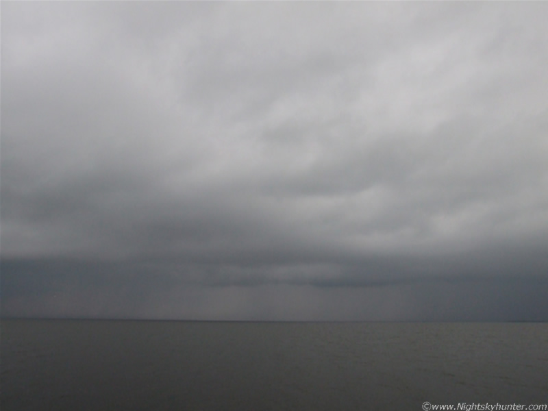
The storm has moved a little closer now as it sailed by to the R. The rain, and probably hail to the R, was really intense looking. It really was so dark under there. The Self Cloud was getting in a better shape now. Some of the lightning was flickering on the far side of the rain curtain on the E shore and no bolts would be seen. A rumble would let me know when one of those unseen bolts fired out.
 |
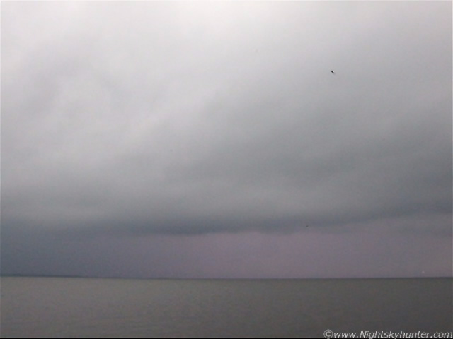
This is probably the closest I have come to getting a daylight still image of a bolt. You can't see it because it was on the other side of the rain. I just happened to press the shutter at the very same moment the lightning flashed. You can see the colour of the rain has changed due to the lightning. That was lucky because the shutter speed was around 2000/sec.
 |
As the evening drew to a close the most spectacular sight occurred. With the dark rain under the Shelf not much could be seen as the evening light grew dark casting low shadows. Then a flash of lightning would erupt and completely illuminate the precip curtain a vivid pink colour. This was so cool. At its peak I seen double and triple pink flashes, then darkness would descent again. Here's another video still showing the pink colour.
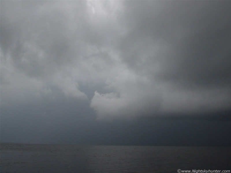 |
Rain was falling on me now. The intense rain core was not over me but persistent light rain from other stratoform cloud began to drift in over me from behind. The camera began to get very wet indeed but I didn't care. For this stage I actually set up my camera and tripod IN the Lough. The above image shows the rear of the storm where the Shelf and most dense part of the precip core met. There was a dark green colour from that rain curtain. You can see the rain falling on the surface of the water. I was really hoping to see a funnel cloud or waterspout here but it wasn't going to happen on this day.
 |
This part of the storm produced some stunning pink I-c bolts of grouped in pairs and triplets. The above video still was the best of the lot. This still doesn't do it justice. It looks great on the high res video I have. The bolt is visible to the far L of frame. That lightning was getting pretty close now and with the rain getting heavier I thought it was time to seek the shelter of the car. If you are hearing thunder then you are already at risk. I was amazed to see Children playing in the park out in the rain on the metal swings. I thought it was very foolish of the parents to leave them out when there was lightning about. Of course the parents where inside and safe!. We got chatting to some of the boat owners who told us about the horrific hail storm earlier which had forced them to come ashore.
Here's an edited video clip. The compression really kills the quality but it captures the surreal atmosphere very well. The lightning is difficult to see on the clip but they look great on the original video. The sound of wind against the camera is not wind at all, it's distant thunder crossing the Lough. It's difficult to hear though. The best rumble is at the very end of the clip when the storm was at it's closest.
Just as the storm came inland it suddenly died and no more lightning was observed. We watched the Shelf pass us by while enjoying a well deserved ice cream from a local shop. It had been a very exciting and satisfying evening. This was my second thunderstorm of the season, I was so delighted I decided to come here, had I stayed at home, I would have seen nothing. On the drive back we left in our wake a wet road to be replaced by the once again bone dry road on our way to Magherafelt. The sky to the W on the road home was like a scene from the US plains. The red disk of the Sun could be seen easily with the naked eye against a backdrop of hazy sand-coloured cloud. Below where dark clouds from outflow cells, and above was the black updraught base of another spent storm. This base would periodically act like a filter blocking the Sun's magnitude and presenting it's perfect sharp disk then brighten again. All this was happening with ever increasing colour intensity with the dark Sperrin Mountains below. It was the perfect end to a perfect day.
Back at home I checked the sferics and was surprised to see that it began producing lightning again during evening twilight. It moved far to the SW of the Lough and eventually died out as it crossed the border. It had been busy for a very long time!. The potential Mesocyclone/HP Supercell potential I found about later really was the icing on the cake. I will be back to Lough Neagh again for round two in the hope of getting a more impressive structure in that area. I hope to catch a waterspout over the Lough some day. To see a storm this good in April, so early in the season, is really something. I'm sure it has set the scene for a very lively Summer ahead. I can't wait. Thanks for reading.
Martin McKenna