
 |
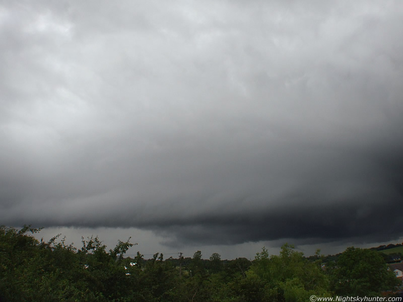
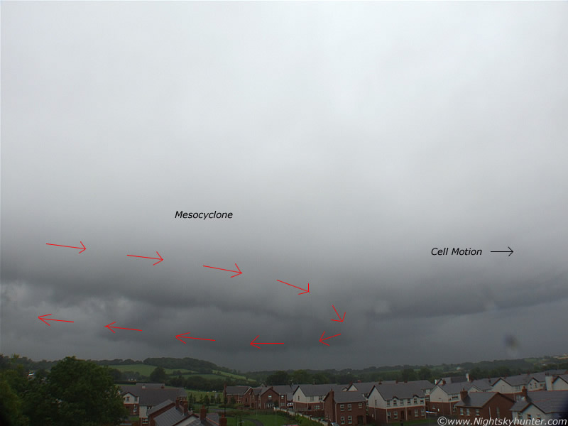
The Meso is now very long!
 |
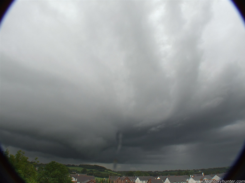
Huge rotating updraught, inflow bands etc. This could be a Low Precipitation (LP) Supercell.
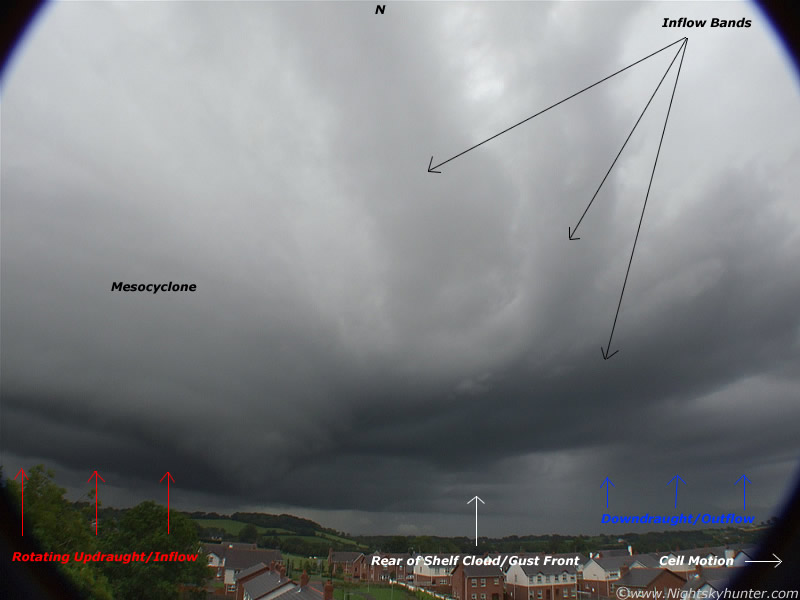 |
I have annotated this image so show the main storm structures. To the L is the danger area with wild rotation. To the R near the ground is the back of a giant shelf cloud/gust front where precip is now falling. I have marked three of the main inflow bands. There are probably more in that area. You can see that the inflow bands are curved due to the rotating cell drawing the bands in as the Meso cranks around. The inflow bands are the visual indication that the storm cell is feeding. By that I mean it's drawing in moisture from the air around it. Since moisture condenses into cloud, this forms bands. I'm not sure what the bulges are on the inflow bands. That shelf looks impressive. The cell is moving from L to R but also away from me into the distance. If I was located further N on the other side I would have seen a stunning shelf/gust front heading my way. I'm glad I was on this side to the S. It just goes to show the potential danger with these cells. If that Meso had dropped a strong tornado and you where located further N you would be unaware of what was coming. You would see the big gust front and then get hit by the precip curtain which would reduce visibility. Behind this curtain the tornado would be waiting to take you literally by surprise.
 |
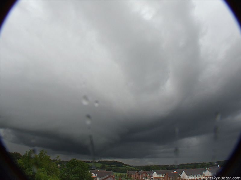
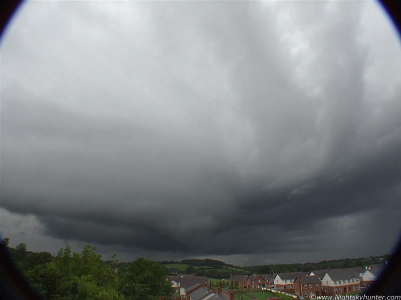
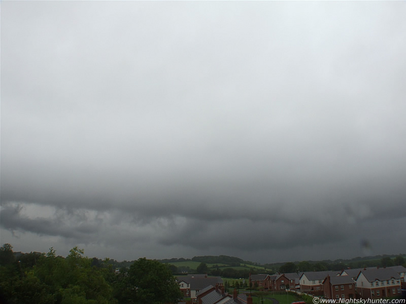
Meso continues spinning and tilting
 |
Perhaps as many as five inflow bands now. The Meso slopes down on the R side and is tilted towards me. Note that the entire thing doesn't fit in the super wide angle lens. At this point in time it's extending from the W to NE sector!.
 |
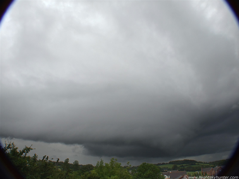
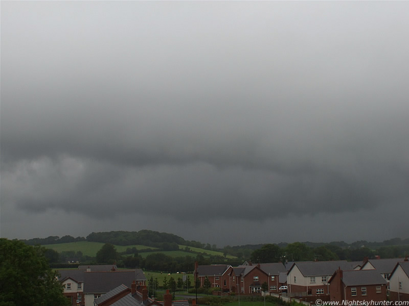
A rare image free from rain drops on the lens.
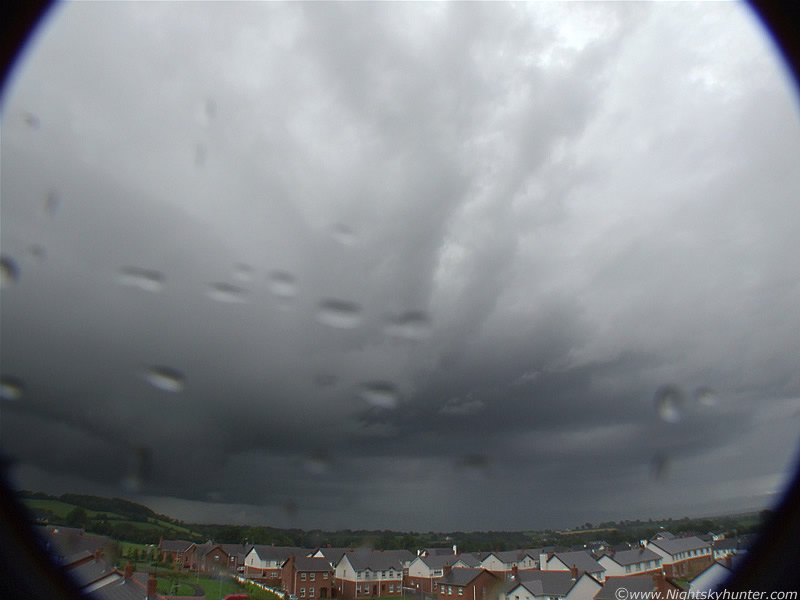 |
I think this is a very dramatic shot. Look at the rotating Meso on the L, you can now see inside it. The rotating walls are very deep!!!. The full length of the shelf and inflow bands are now apparent. I think the supercell (?) is now outflow dominant. It's producing rain in the sky sector to the NE. Others big showers have moved in from the SW behind me and are hitting the camera lens.
 |
The enormous Meso is now directly N and rotating over those fields above Blue Bell Forest. This is only half of the Meso. That's Willow Glynn in the foreground where I live. Beyond this is open countryside. The villages of Swatragh and Garvagh are miles beyond this.
 |
I have annotated this image to help new people visualize what's going on here.
 |
This is a huge Meso. By looking at that area of country I would estimate that the area of rotation is longer than two football pitches end on end. In fact, it's probably much longer!.
 |
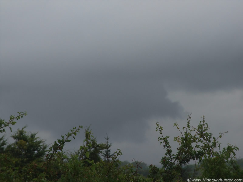
Precip is falling near the updraught now. This entire area is now rain-wrapped. By that I mean that the curtains of rain are rotating. Imagine standing under them and seeing a dense curtain of rain rotating around you.
 |
This was taken earlier when the cell was approaching from the NW. This is a large wall cloud hanging down from the rain free base. It was boiling and turbulent showing signs of rotation in a horizontal and vertical plane. I think this the closest I have come to seeing a strong tornado form to date.
This is a youtube video I made consisting of seven video clips I put together taken at various times. Each clip shows just how much the cell had changed during the period. Check out around 2 min's 50 sec's when the camera pans from the updraught base up to the plume overhead. You can really appreciate the height. You can't see the rotation in the video due to the wide angle lens. I hope the images, video, and written description help to recreate what it was like to see this thing.
This cell had an obvious Mesocylone, this combined with the structures has convinced me that this is a good case for an LP Supercell over N. Ireland. It didn't produce any severe weather that I know of except rain. However, it would have formed long before it arrived over Maghera. Further W it would have resided miles away over the Sperrin Mountains. These mountains and the country beyond are just miles of mountains, hills, fields and marsh land. There would have been very few people out there on this wet day except a few farmers or hikers, so who knows what it was doing during that period. Recalling the sferics earlier it could have produced some lightning or hail, even a tornado over the hills but no one would have seen it. The cell slowly drifted away from me and the view was obscured by new showers and I never seen it again. I estimate that during the entire period of observation when I first spotted it earlier, it must have been rotating for 1.5 hours, probably longer. That's a persistent rotating updraught!. When it was gone I immediately went back on the computer and reported the sighting to the UKWW in quite an excited manner. I followed this up several days later with images and an account to the same place. Everyone agreed that this did indeed look like it had a Mesocyclone. Don't think of a Supercell as a cloud, it's a machine which transports moisture from the ground into the top of the atmosphere. Here's more information...
A mesocyclone is a vortex of air, approximately 2 to 10 km in diameter (the mesoscale of meteorology), within a convective storm. That is, it is air that rises and rotates around a vertical axis, usually in the same direction as low pressure systems in a given hemisphere. They are most often cyclonic, that is, associated with a localized low-pressure region within a severe thunderstorm. Such storms can feature strong surface winds and severe hail. Mesocyclones often occur together with updrafts in supercells, where tornadoes may form. Mesocyclones are believed to form when strong changes of wind speed and/or direction with height ("wind shear") sets parts of the lower part of the atmosphere spinning in invisible tube-like rolls. The convective updraft of a thunderstorm is then thought to draw up this spinning air, tilting the rolls' orientation upward (from parallel to the ground to perpendicular) and causing the entire updraft to rotate as a vertical column. Mesocyclones are normally relatively localized: they lie between the synoptic scale (hundreds of kilometers) and small scale (hundreds of meters). Radar imagery is used to identify these features.
The best way to detect and verify the presence of a mesocyclone is by Doppler weather radar. Thus the word mesocyclone is associated with weather radar terminology. Mesocyclones are most often identified in the right-rear flank of supercell thunderstorms and squall lines, and may be distinguished by a hook echo rotation signature on a Doppler weather radar map. Visual cues such as a rotating wall cloud or tornado may also hint at the presence of a mesocyclone. This is why the term has entered into wider usage in connection with rotating features in severe storms.
Mesocyclones are believed to form when strong changes of wind speed and/or direction with height ("wind shear") sets parts of the lower part of the atmosphere spinning in invisible tube-like rolls. The convective updraft of a thunderstorm is then thought to draw up this spinning air, tilting the rolls' orientation upward (from parallel to the ground to perpendicular) and causing the entire updraft to rotate as a vertical column. As the updraft rotates, it may form a wall cloud, a spinning layer of clouds descending from the mesocyclone. The wall cloud tends to form closer to the center of the mesocyclone. As it descends, a funnel-shaped cloud may form at its center. This is the first stage of tornado formation.
The presence of a mesocyclone is believed to be a key factor in the formation of the strong tornadoes associated with severe thunderstorms. Tornadoes typically form at the peak of thunderstorm intensity as the storm begins to weaken. This is because the momentum and vacuum built up as large masses of air rise into the upper atmosphere cause a siphoning effect nearer to the ground. As the updraft is restricted, the entire thunderstorm is fed by smaller pockets of remaining warm air at the ground. The back-pressure created as the warm air runs out sucks the base of the thunderstorm towards the ground (i.e. a wall cloud). Once the warm air at the ground is nearly depleted, the entire top of the thunderstorm and the large wall cloud siphons air from a 1 mile or less diameter region at the ground, forming a tornado. If a moderate supply of warm air is available ahead of the storm, the storm may be tornadic for some time. If the warm air runs out, then the storms essentially chokes itself off and gradually dies.
A supercell is a severe thunderstorm with a deep, continuously rotating updraft (a mesocyclone). Of the four classifications of thunderstorms (supercell, single-cell, multi-cell, and squall line), supercells are the largest and most severe.
Supercells are usually found isolated from other thunderstorms, although they can sometimes be embedded in a squall line. Because they can last for hours, they are known as quasi-steady-state storms. Supercells have the capability to deviate from the mean wind. If they track to the right of the mean wind (relative to the vertical wind shear), they are said to be "right-movers." Alternatively, if they track to the left of the mean wind (relative to the shear), they are said to be "left-movers." Supercells can sometimes develop two separate updrafts with opposing rotations, which splits the storm into two supercells: one left-mover and one right-mover.
Supercells can be any size, large or small, low or high topped. They usually produce copious amounts of hail, torrential rainfall, strong winds, and substantial downbursts. Supercells are one of the few types of clouds that typically spawn tornadoes within the mesocyclone, although only 30% or less do so.
Supercells can occur anywhere in the world under the right pre-existing weather conditions. According to some, the first storm to be identified as such was the Wokingham storm over England, which was studied by Keith Browning and Frank Ludlam in 1962. As with tornadoes in general, they are most frequent in the Great Plains of the United States.
Low Precipitation (LP) supercells contain a small precipitation (rain/hail) core separate from the updraft. This type of supercell may be easily identifiable with "sculpted" cloud striations in the updraft base or even a "corkscrewed" or "barber pole" appearance on the updraft, and sometimes an almost "anorexic" look compared to classic supercells. This is because they often form along dry lines, thus leaving them with little available moisture despite high upper level wind shear. They usually dissipate rapidly rather than turning into classic or HP supercells, although it is still not unusual for them to do the latter, especially if they happen to collide with a much moister air mass along the way. Although these storms usually produce weak tornadoes, they have been known to produce strong ones. These storms usually produce hail less than 1.00 inch in diameter but can produce large hail even with little or no visible precipitation core, making them hazardous to storm chasers and people and animals caught outside. Due to the lack of a heavy precipitation core, LP supercells can sometimes show weak radar reflectivity without clear evidence of a hook echo, when in fact they are producing a tornado at the time. This is where observations by storm spotter and storm chasers may be of vital importance. Funnel clouds, or more rarely, weak tornadoes will sometimes form midway between the base and the top of the storm, descending from the main Cb (cumulonimbus) cloud. Lightning is rare compared to other supercell types, but it is not unknown and is more likely to occur as intracloud lightning rather than cloud-to-ground lightning. In North America, these storms almost exclusively form from the Rocky Mountains to the Mississippi River in the spring and summer months. They can occur as far north as Montana, North Dakota and even in the provinces of Alberta and Saskatchewan in Canada. They have also been observed by storm chasers in Australia. LP supercells are quite sought after by storm chasers, because the limited amount of precipitation makes sighting tornadoes at a safe distance much less difficult than with a Classic or HP supercell.
First of, here's a link to a UKweatherworld thread which addresses this very issue...
http://www.ukweatherworld.co.uk/forum/forums/thread-view.asp?tid=339&start=1
Supercells are rare in the UK but some sources estimate that there maybe as many as five per year in the UK. Others are not so optimistic giving odds of one a decade. The debate still goes one. Of interest was a HP Supercell seen from near Belfast in July 30th 2006 by Martin North which produced heavy hail and a possible funnel cloud. He waited 20 years to catch one in N. Ireland. Here's the link to the UKWeatherworld thread...
http://www.ukweatherworld.co.uk/forum/forums/thread-view.asp?tid=3554&posts=151&start=1
The above thread is very informative with hot debate but I recommend reading it if you live in Ireland or UK and want to know more about these incredible structures.
Since the above images were taken I have been on quite a high, and I still am. It has always been a major goal, even dream of mine, to catch a Supercell/Mesocyclone from N. Ireland. On August 1st 2008 I caught one, of all places near my home!. This is extremely lucky indeed as others have spent years chasing without any. During 2008 I have spent an incredible amount of hours, both day and night, looking for things like this, then suddenly one sails in over my doorstep. After seeing a partial Solar Eclipse and enjoying the excitement of the Maghaberry funnel cloud, this was the unexpected icing on the cake. This is a day which I will never forget. The action wasn't over yet because another outlook was issued for Saturday which produced another good convective haul. These will feature in my next image account. Who knows what will appear next...oh yea, I never did get to eat that pizza!.
Martin McKenna