
Saturday July 4th 2009. TORRO convective forecaster Tony Gilbert issued a forecast for parts of Ireland, N. Ireland, and Britain for a moderate risk of powerful thunderstorms thanks to an unstable sly moist flow, strong solar heating and high instability all helped by a trough crossing the country and a number of convergence zones which would trigger thunderstorms just about anywhere during the afternoon and evening. I had been looking forward to this day for a week in advance from watching the models and crossing my fingers that the CAPE and LI values wouldn't get downgraded at the last min. This was an action-packed week for weather with a wide spread thundery breakdown over the UK as a result of the hot temps and humidity we had which made sleeping very uncomfortable at night. Mainland Britain got plenty of storms during the week but it was N. Ireland's turn on Saturday, Sunday, and Monday, with Saturday looking to be the best day of the three. I was up early on Saturday morning and checked the latest GFS charts and was pleased to see a great set-up. I could tell from mid day that there was a high probability of a thunderstorm in my own area just from looking at the spectacular convection around.
By early afternoon I went out to my favourite spot in the countryside after having my last of about 50 checks on the radar, and waited. Intense showers and storms where breaking out over central Ireland and crossing the border into N. Ireland and their generally S to N track indicated that they could approach my area later. So I spent several hours out under the hot Sun in a very humid atmosphere watching the convection grow and grow. The sky was filled with impressive towers with expanding mushroom tops showing evidence of shear so I was watching out for funnel clouds from their bases. The W section of the sky had more vigorous convection so I just watched these lines of towers pass me by hoping for something to drop from them while a Squirrel watched me from close range. I observed something interesting to my SW literally on the horizon in the region of sky between the W side of Slieve Gallion and W Sperrins. A huge cell had dropped a large lowering shaped like a dark inverted bowl onto, what looked like, the ground. This 'bowl' looked like a wedge tornado and showed rapid movement and shape-shifting even from that incredible distance away. It had several vertical appendages on either side of the bowl which also made strange movements, however being so far away I couldn't be sure what it was. I did consider the possibility that this may have been a tornado, it stayed close to the ground for 10-15 min's before I lost it from view behind the mountains. If it was the real thing, it probably went unnoticed due to the barren area of the mountains it was located over. I have never heard any reports since.
After several hours it was just after peak heating time and approaching 18.00 BST. The sky was gradually changing and it didn't take a genius to work out that something big was gradually approaching. The sky was very dark to my S and SW and filled with cu fields and mid level cloud blocking the view however I was convinced that a storm was moving closer. I decided to go back home and check the radar...confirmed, a large cluster of thunderstorms with bright red and white radar returns where located to my S and moving N. Judging from the radar these looked to be organized multicells producing torrential rain. I logged onto the UKweatherworld forum and checked out the convective/thunderstorm reports threat. Greg Loyd from N. Ireland had been on while I was out and had posted excited observations about an incredible cell with solid anvil, straight back, and overshooting top which he had photographed from 50 miles away. He said it was to his SW and heading for me and asked if I could see the anvil. I said I couldn't because of the mid level cloud but told him I would keep a look out. He was amazed I couldn't see it due to its massive size. Tony Gilbert said that these were quite possibly severe cells based on their radar signature.
I had a quick mug of tea then walked out to my back garden to check the sky...this was when I got a delightful shock. There were large gaps in the cloud, and looking directly at the zenith I could see the monster anvil from that severe cell, it was absolutely enormous extending from the S, overhead, and drifting rapidly over me into the NE sky sector. I looked back to the S expecting to see the storm itself however there was nothing visible except a thickly clouded dark sky. That's when the true size of this beast really hit me, I was thinking ''OMG, OMG'' and walking around the garden excited trying to figure out where to go. I could easily visualize what was going on. This storm was miles away, not even visible visually, yet the anvil from the storm had been blown downwind ahead of the storm for tens of miles turning the sky overcast. Another look up and I could see mammatus under the anvil in two different sectors of the sky, to the W and E, not the kind of mammatus which indicated a weakening cell, so common with Winter convection here, but the kind that indicated healthy and powerful updraughts at upper levels of the atmosphere.
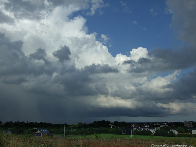
I considered taking images but I thought what was the point?, it was too large, even the wide angle 28mm lens would have been just a postage stamp section of the entire thing which wouldn't do it justice. I didn't waste anymore time and decided to go back out to my local spot on high ground. By the time I got there I was really overheating, the sky looked dark and cool but it was nothing like that at ground level. I took off my jacket and set-up the camera wearing only a t-shirt. The anvil now covered the entire sky while dark mid level cloud raced across blocking everything from view so I just stood there watching towards the S and SW. After a long wait I saw the storm approach along the distance horizon. There were two things going on here. To my SW (R) was an outflow dominant cell which was dropping heavy rain and large sections of outflow cloud/scud across the mountains.
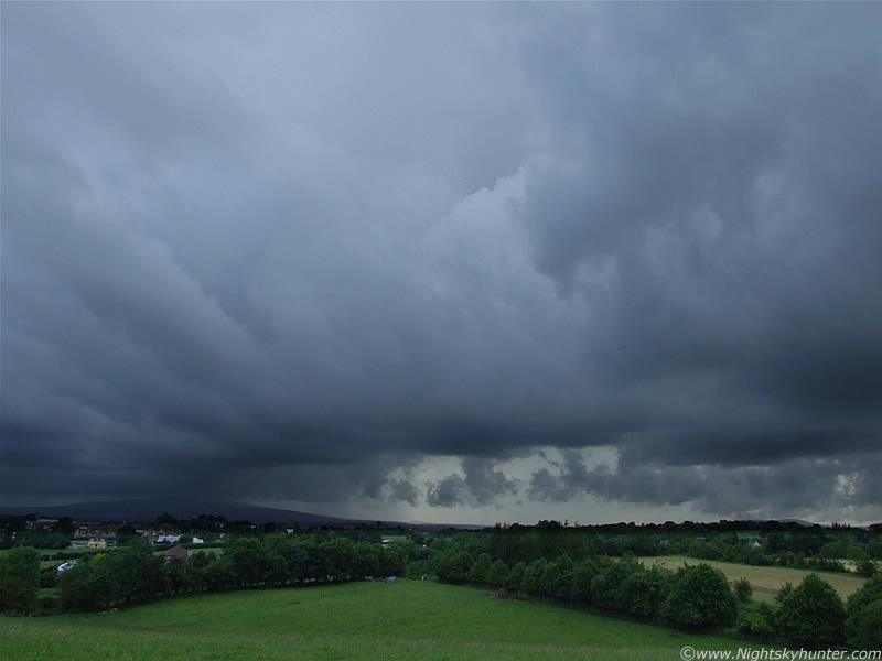 |
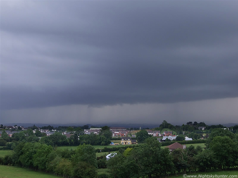
This is that scene. Dense precip (yellow in colour with naked eye) with large scud where blowing across the Sperrins and at times they almost seemed to be touching the mountains themselves. These from the outflow cell are visible on the RHS of the above image. They are moving by me to the R into the N. The dark mountain LOC is Slieve Gallion and it was here that I could see the big storm (other thing) approaching fast from the S. At first it was dark cloud, then below a distant precip curtain could be glimpsed above the local horizon which slowly grew larger.
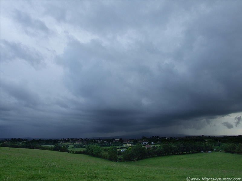 |
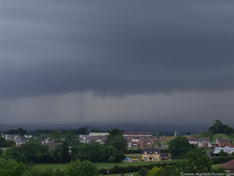
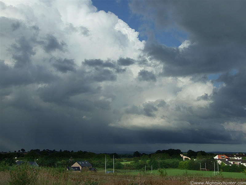
I watched it advance from behind Slieve Gallion with low hanging scud teeth marking the gust front/shelf cloud ahead of the precip. In the image above the storm has got alot closer, the gust front was not notable for its brilliant structure, however it was massive, dark, and had horizontal ridges along it's lip. The leading edge of this huge storm cell stretches out of frame on either side of this image taking up the SW to SE skyline. The precip curtain is now creeping over the crest of the mountain and falling down on my side, and heading this way.
 |
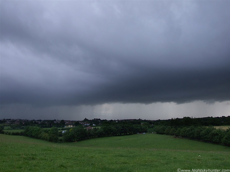
Closer still
 |
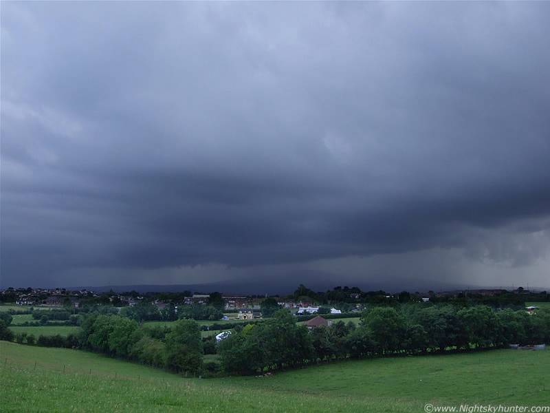
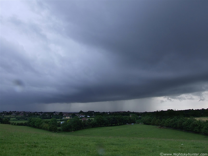
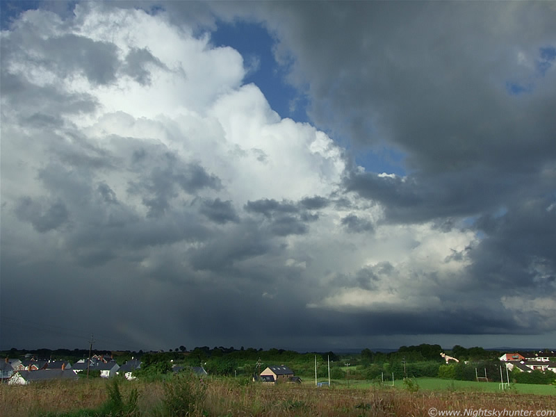
Now the mountains are completely obscured by that tremendous precip curtain. What you can't appreciate from these images is the nasty appearance to that falling rain. I honestly thought it was frightening looking and quite evil in appearance. Tremendous rainfall was getting dumped along the slope of that mountain and heading for Maghera, it was so dense and silvery-dark that nothing could be seen through it. The curtain seemed to grow stronger and more menacing by the min with eye-catching dark lines splitting the curtain into vertical streamers. I could see these moving in real time so I knew this storm was going to pack a punch when it hit, my adrenalin began to flow.
 |
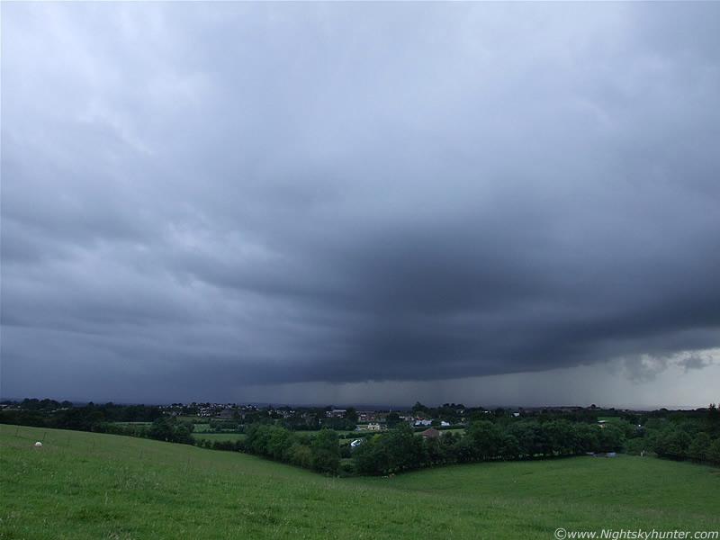
Approaching Maghera
 |
Thick streamers of intense rain broke out within the main curtain. There was serious rainfall here. Both of the above shots were taken with the zoom lens. The sky was alot darker than this but I had to use a longer shutter to bring up the foreground.
 |
Even though the storm was some distance away, spits of rain where hitting the camera from the outflow winds. The shelf was sporting some better structure here. Now the race was on to get images before the storm arrived, there was no way I could continue shooting when that torrential rain hit me. It's visible across the entire sky here. I was taking still images, switching to video, then wiping the rain drops from the lens, then back to stills. I put my water proof jacket back on now. A bright white flash of lightning appeared to the lower L behind the precip curtain, still too distant to hear the thunder now that the wind had picked up.
 |
Another flash, this time from the RHS behind the precip. The storm should be close enough to hear the thunder any time I thought. I then saw a stunning blue coloured c-g bolt hit down in front of me which was spectacular, it actually hit outside the precip area ahead of the storm which really put my nerves on a knife edge and I began to get concerned for my safety. I thought about all the recent reports over the last two weeks of Horses, Cows, Sheep, and people, all killed by lightning in the UK and I began to get worried. That bolt showed that the c-gs were unpredictable, they could hit down anywhere. This was followed soon after by a very loud 'gun shot' crack of thunder which was thrilling to hear.
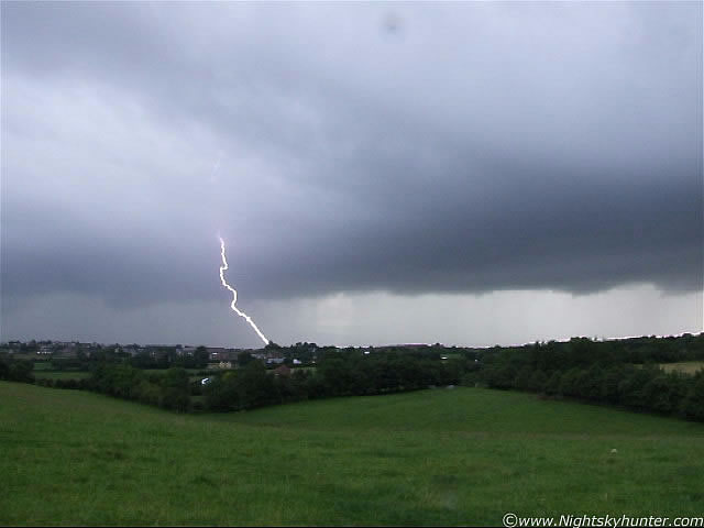 |
Here's the video still of that c-g. Looks to have hit down somewhere in the SW part of town. Half way up the image you can actually make out a second part of the branch emerging from the cloud indicating that the bolt came from high up in the storm. There's a possibility that this came down from the anvil (far above and hidden by cloud) itself and may even have been a positive bolt, although that's just speculation on my part.
The storm rapidly approached me with the rain and gust front taking up all of my vision while more lightning flashed and thunder cracked. I took cover in our car with a member of my family and together we watched the lightning illuminate the heavy rain. This storm produced the worst isolated rainfall event I have seen from any storm this Summer, it was absolute torrential which reduced visibility so bad at one stage that we had trouble seeing the road even with the lights and wipers on. The rain made one hell of a sound on the roof and front windscreen accompanied by gusty winds. At its worst it was quite amusing to see a young Man driving a tractor down the Coleraine Road directly under the core of the storm, the thing is, the tractor had no cap at all, so he was just sitting there on a little uncomfortable seat bouncing around and getting battered by torrential rain and flashing lightning. I bet his nerves were shot too, I didn't know how on Earth he was able to see the road in that. You can see him briefly on the video clip below. We drove on home and eventually we emerged out from the rear of the precip curtain and could see the sweeping anvil overhead and flanking line at the rear while thunder still rumbled. The Sun broke out and the sky turned quite gorgeous. I walked up to a high vantage point near my home and watched the storm retreat into the NE with a huge proud white precip core at the rear. That view reminded me of the great thunderstorms I observed during 2007 from the exact same place. It brought back good memories, although the 2009 season is currently much better!. Some of the thunder seemed to last a very long time which again reminded me of the strange long duration rumbles I heard in 2007, I read somewhere that thunder like that can be a sign of severity but don't quote me on that.
The Sun broke out and produced a stunning set of primary and secondary rainbows with vivid colours andsupernumerary arcs at the back of the storm which was quite breathtaking against a background of white convective tops. The base of each bow looked incredibly close range within the grounds of St. Patrick's pitch. While this fine optical display showed off I could hear regular angry rumbles of thunder at the same time which was a surreal experience. The rain was still falling so I couldn't get any decent stills although you can see a bit of these bows on the video which doesn't really do justice to them. I went back home again, checked the radar and forums to see what was happening. More thunder got my attention and when I looked out my window I could see a second storm heading for Maghera not far behind the first one. The rain from this was quite intense and the thunder was good, although not as frequent as the first storm. Once it passed over my home I had another look outside and good see a gorgeous flanking line emerging into view so I went back out again to check it out.
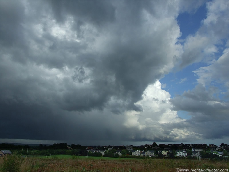 |
This is looking E at the second storm (moving R to L). The mid level cloud began to clear and the Sun lit up this beautiful flanking line at the rear of the storm, which at this stage, was an obvious multicell. Here the base of the flanking line (R) merges into the long dark base of the storm (L) which extended from the SE to N sky sectors far out of frame to the L. The towers at the rear were exploding up and sported the classic high quality crisp solid look which I like to see in good storms.
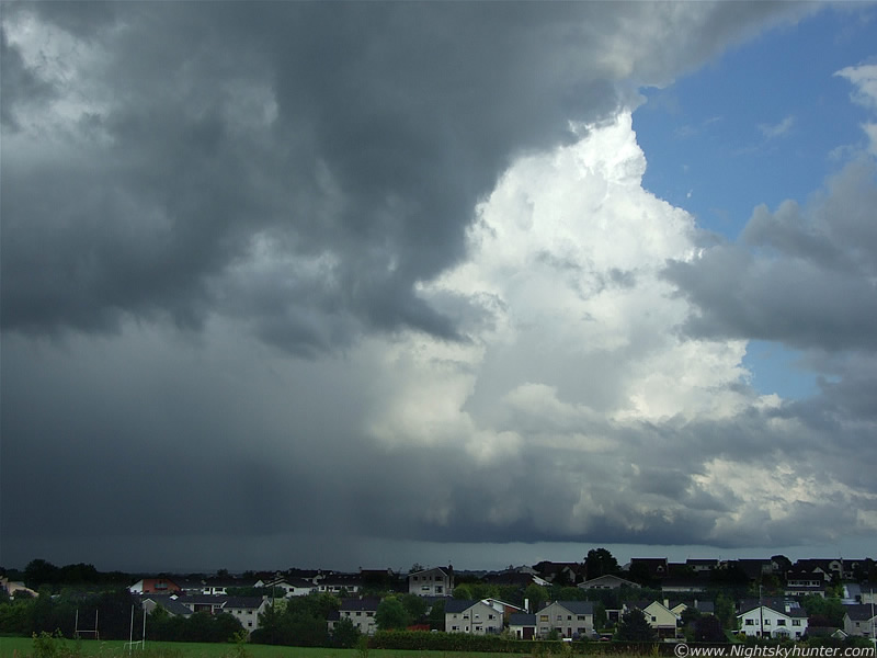 |
This line was really big, later I learned that soundings showed that the cb tops where +30,000ft high. This is zooming in a little on that flanking line. There are two areas of storms I like to see for structure, the first is the gust front/shelf cloud, if you are positioned well ahead of the storm you can watch it approach you from the distance providing you with the chance to get some shelf structure shots and watch/image the lightning. Once the outflow hits you then you are pretty much out of the game unless you are in a sheltered location or car to catch the lightning among the heavy rain. The next opportunity is when the rain has passed away and you can see the rear of the storm. Here you can monitor the main updraught, rain free base (if there is one), and flanking line/new updraughts. This is the place all chasers want to be, for it is here where a funnel cloud or tornado could drop. From looking at the quality of that powerful convection and well defined base I had a good feeling about something forming. That something soon did. To the R of the frame, at the base of those white updraught towers, I saw a very brief funnel cloud form very rapidly. It was white in colour and shaped like a rope and could be seen spinning like a top even at that considerable distance away. It's snout curved upward and the funnel lifted into a horizontal position, bent at centre, then quickly retracted back into the base and it was gone. By the time I got my camera zoomed in and focused the show was over!. I missed it on camera but at least I seen it, I was rather chuffed to say the least.
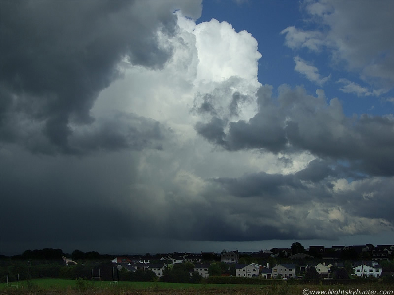 |
Storm moving further N (L) with the constantly evolving updraught tower at the flank. Thunder still boomed from time to time.
 |
I kept my eyes glued to the dark base and crossed my fingers that a stunning funnel or tornado would drop down there. The dark mid level patches of cloud made for a nice scene contrasting against the white convection.
 |
A little lowering appeared to the R but amounted to nothing.
 |
A faint section of bow is visible to the lower L on the falling precip. I stayed here and watched this line move further away with the occasional rumble and when I was convinced no further funnels would form I went back home. Below is a video of some of the scenes, I only managed to catch the one c-g and a few rumbles along with some heavy rain, bows, with footage of the flanking line.
Checking back on the radar I could see another line of storms and new cells to my SW moving N and despite being a large distance away I could see them visually from home and they looked absolutely incredible. The convection was phenomenal, rock solid, huge, and exploding with such energy that it was difficult to believe for this time of the evening with the Sun getting low in the sky. We decided to go out chasing and tried to pursue those new lines of powerful convection. We drove all over the place, the countryside outside Maghera, Glen Shane Pass, Tobermore, outside Draperstown, along the flank of the Sperrins, however we just couldn't get close enough, those monster cells where further away than they looked. Finally we stopped up the flank of Cairn Mountain and watched those cells for a long time bubbling up in the gorgeous late evening Sun. The anvils to the W and SW where enormous with mammatus under the anvil canopies which swept across the Troposphere for miles with solid vertical hard backs and erupting mushroom-shaped towers and flanking lines. They were a breathtaking sight all back-lit by the Sun with dark bodies and pink crowns where the sunlight filtered through. On the drive back home, just before sunset, we could see another volcanic dust sunset with highly structured white bands between the dark convective clouds, what a great end to a thrilling day. This fantastic storm season continues to amaze me, that's 14 storms and 6 funnel clouds I have seen this season with some of the finest convective structures and cells I have ever seen in my life. I hope there's more to come. Thanks very much for reading.
Martin McKenna